es.tu.ar.y (es-chew-wer-ee), n. 1. that part of the mouth or lower course of a river in which the river's current meets the sea's tide. 2. an arm or inlet of the sea at the lower end of a river.
(Random House Unabridged Dictionary, 1993)
About Estuaries in Oregon
Oregon's 22 "major" estuaries play a vital role in the ecological and economic health of the coast and the entire state. For example, they are ecologically important to many fish and wildlife species, providing migration routes and habitat for reproduction, rearing, resting, and foraging. Healthy estuaries provide important habitats for many species we value such as salmon, herring, flounder, crabs, oysters, clams, wading birds, ducks, geese, shorebirds, and harbor seals.
Oregon's estuaries also serve coastal communities. Deep draft shipping, commercial fishing, port facilities, other businesses that depend on water access, and recreational uses are examples. Providing for these and other uses while protecting estuarine ecosystems and natural resources is the key challenge for public agencies, non-governmental organizations, private businesses, and users.
Each of Oregon's estuaries is a unique ecosystem influenced by many variables - watershed size, geology, and land use; river gradient; the estuary's shape and size; and annual patterns of precipitation, river runoff, solar heat input, ocean tides, and fresh water-salt water mixing. To learn more about a specific estuary select one from the list below.
Oregon Estuaries North to South
|
|
|
|||||||||||||||||||||||
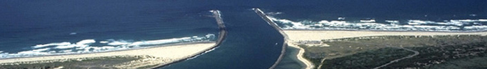
| South of the Coquille River estuary at Bandon are six small estuaries-the Sixes, Elk, Rogue, Pistol, Chetco, and Winchuck. The estuaries of these steep-gradient rivers extend only a few miles upstream at most and have gravelly bottoms and little tideland. These rivers drain out of the rugged Klamath Mountains and, except for the Rogue, have relatively small watersheds. During the summer, when flow becomes extremely low, the Sixes, Elk, Pistol, and Winchuck estuaries sometimes close off at the mouth as sand berms pile up and clog the entrance. The Rogue, like the Umpqua River to the north, drains a large watershed with headwaters high in the Cascades. | |||||||||||||||||||||||||
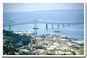 The Columbia River estuary, with more than 80,000 acres of surface area in Oregon alone, is larger than all of the other Oregon estuaries put together. Draining one of the largest river basins in North America (259,000 square miles), the Columbia's estuary is dominated by the river's freshwater inflow. Although the head of tide extends 146 miles upstream to Bonneville Dam, traces of salt water rarely are found above River Mile 30, even at low flow. The freshwater nature of this estuary makes it very different from the smaller estuaries to the south. For example, of the more than 10,000 acres of Columbia estuary tidal marsh, only a small fraction is salt marsh. The rest are freshwater tidal wetlands.
This text abridged from Estuarine Science, Management and Restoration provided by Jim Good, OSU