About the Coquille River Estuary
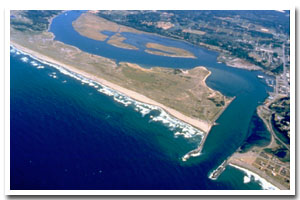
The Coquille River estuary is located on the Oregon coast at Bandon, Coquille and Myrtle Point. The estuary is approximately 1082 acres in area and has a watershed of approximately 1058 square miles.
The Coquille River estuary is designated as a Shallow Draft Development estuary under the Oregon Estuary Classification system. The geomorphology of the area is that of a Drowned River Mouth estuary.
The Coquille River estuary is located in Coos County. Timber and fishing are the foundation of the county's economy. The area also produces large quantities of shell fish. In addition vacation and recreational possibilities, such as the National Dunes Recreation Area and many state parks, attract tourists to the area and provide an additional economic stimulus. There are several port districts in the county: Port of Coos Bay founded in 1909, Port of Coquille River founded in 1912, and Port of Bandon founded in 1913. Coos Bay is considered the best natural harbor between San Francisco Bay and the Puget Sound and the Port of Coos Bay is the largest forest products shipper in world. The first census in 1860 showed a population in Coos County of 445. The 1997 population of 61,400 represented a 1.9% increase over the 1990 population.
In a forest behind overgrown dunes, Bullard's Beach State Park's campground is sheltered from the beach's north winds. Picnic lawns are a stone's throw from the Coquille River and a popular boat ramp. Shorebirds, geese, ducks, and osprey visit the salt marsh of the Coquille River estuary. Visit the North Jetty near the lighthouse to watch brown pelicans dive for fish. |
Data for the Coquille River Estuary
[59 Records Listed]
Coquille River Estuary GIS Data |
Data Layer |
Source |
Scale |
Year |
Download |
|
OCMP |
1,000 |
1979 |
|
|
OCMP |
1,000 |
1986 |
|
|
OCMP |
1,000 |
1979 |
|
|
OCMP |
1,000 |
1986 |
|
|
OCMP |
1,000 |
1986 |
|
|
OCMP |
1,000 |
1979 |
|
|
NOAA |
10,000 |
2000 |
|
|
ODA |
200,000 |
1999 |
|
|
ODFW |
100,000 |
1998 |
|
|
USACE |
100,000 |
1995 |
|
|
ODFW |
100,000 |
1998 |
|
|
FEMA |
24,000 |
1998 |
|
|
BLM |
50,000 |
1993 |
|
|
USGS |
500,000 |
1993 |
|
|
USFS |
24,000 |
2000 |
|
|
DOGAMI |
50,000 |
1992 |
|
|
OWRD |
100,000 |
1999 |
|
|
BLM |
24,000 |
1999 |
|
|
ODFW |
100,000 |
1999 |
|
|
Ecotrust |
58,000 |
1857-1872 |
|
|
USFS |
12,000 |
1994 |
|
|
USFWS |
58,000 |
1995 |
|
|
USFS |
24,000 |
1996 |
|
|
SSCGIS |
100,000 |
1993 |
|
|
DLCD |
24,000 |
1999 |
|
|
EPA |
100,000 |
1996 |
|
|
USGS |
24,000 |
1997 |
|
|
USFS |
12,000 |
1994 |
|
|
BLM |
24,000 |
1999 |
|
|
DEQ |
100,000 |
1998 |
|
|
USFS |
24,000 |
1999 |
|
|
BLM |
24,000 |
1995 |
|
|
ODFW |
100,000 |
1998 |
|
|
TIGER |
100,000 |
1998 |
|
|
EPA |
Unknown |
1998 |
|
|
SSCGIS |
250,000 |
1914 |
|
|
USFS |
24,000 |
1999 |
|
|
BLM |
250,000 |
1900 |
|
|
OWRD |
24,000 |
1999 |
|
|
ODFW |
100,000 |
1998 |
|
|
DLCD |
100,000 |
1986 |
|
|
OCMP |
10,000 |
1945 |
|
|
USGS |
24,000 |
1994 |
|
|
USGS |
24,000 |
1994 |
|
|
USGS |
24,000 |
1994 |
|
|
USGS |
24,000 |
1994 |
|
|
USGS |
24,000 |
1994 |
|
|
USGS |
24,000 |
1994 |
|
|
USGS |
24,000 |
1993 |
|
|
USGS |
24,000 |
1973 |
|
|
USGS |
24,000 |
1973 |
|
|
USGS |
24,000 |
1980 |
|
|
USGS |
24,000 |
1999 |
|
|
USGS |
24,000 |
1983 |
|
|
OCMP |
0.25 m |
2005 |
|
|
OCMP |
50,000 |
2014 |
|
|
OCMP |
50,000 |
2014 |
|
|
OCMP |
50,000 |
2014 |
|
|
OCMP |
50,000 |
2014 |
|
[59 Records Listed]
Information provided by the Oregon Coastal Management Program |