Description
0.6 miles of intertidal area and associated rocks, about ten miles south of Newport off HWY 101 near the town of Seal Rock, Oregon. |
|
Designation
The beaches and rocky shores of Oregon are part of Oregon’s Ocean Shore Recreation Area. |
| |
|
|
Key Resources
Diverse intertidal communities and limited seabird nesting, some use of associated rocks by harbor seals and limited seabird nesting. |
|
What can you do here?
High use of the area by the general public for recreational sightseeing, beachcombing, tidepooling, bird watching, clamming, and rock fishing. Some use by school groups for educational field trips. Contact the South Beach SP management unit for more information about the rocky shore interpretive program at Seal Rock (541-867-7451). |
Educational Opportunities
Oregon Parks and Recreation Department has a seasonal rocky shores interpreter who conducts tidepool walks at this site. There are a variety of interpretive signs present at this site including the ODFW “Welcome to Our Home” rocky shores poster, geologically oriented signs (“Volcanic Rock”), one on cultural resources (“Human Use”), tidepool etiquette (“Watch Your Step”), and several NOAA/Sea Grant posters on the cluster board near the parking lot (“Domoic Acid and Amnesiac Shellfish Poisoning”, “Sea Foam”, “Velella velella”, and “Rip Currents-Break the Grip of the Rip”).
Getting to the Rocky shore at Seal Rock
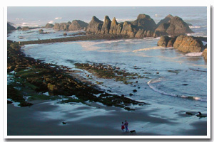
The area is immediately adjacent to Highway 101 and Seal Rock State Recreation Site and has easy access from several points. Primary access is via Seal Rock State Recreation Site with some access from the south near the RV Park. Access to offshore rocks (such as those pictured in the photo, above) is prohibited as they are part of the Oregon Islands NWR and are important habitat for nesting seabirds and marine mammals. Even rocks that are accessible at extreme low tides may be part of the Oregon Islands NWR. If the rocks are not connected to the land at high tide, they are part of the Oregon Islands NWR.
 Public Access Option 1 for Seal Rock Rocky Shore Public Access Option 1 for Seal Rock Rocky Shore
 Public Access Option 2 for Seal Rock Rocky Shore Public Access Option 2 for Seal Rock Rocky Shore
Public Access Option 3 for Seal Rock Rocky Shore
Who Owns this Site?
Submerged and submersible (intertidal) lands: Division of State Lands; rock area above Mean High Water: U.S. Fish and Wildlife Service; beach and upland wayside: State Parks and Recreation Department; highway right-of-way and pullouts: State Department of Transportation Highway Division; remaining upland: private ownership. |
|
Who Manages this Site?
 Offshore rocks are managed by the USFWS as a National Wildlife Refuge. Oregon Parks and Recreation Department manages the site as Seal Rock State Recreation Site, which is part of OPRD Area 1 and the South Beach Management Unit. The beaches and rocky shores of Oregon are part of Oregon’s Ocean Shore Recreation Area, which is managed by the Oregon Parks and Recreation Department. Offshore rocks are managed by the USFWS as a National Wildlife Refuge. Oregon Parks and Recreation Department manages the site as Seal Rock State Recreation Site, which is part of OPRD Area 1 and the South Beach Management Unit. The beaches and rocky shores of Oregon are part of Oregon’s Ocean Shore Recreation Area, which is managed by the Oregon Parks and Recreation Department. |
|