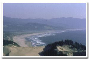
About the Neskowin Sandy Shore
Here identified as the Neskowin littoral cell, this sandy 12 mile segment of Oregon's coastal shoreline extends from mileage Cape Kiwanda to Cascade Head. It is associated with the Nestucca and Little Nestucca rivers mouth(s) and accompanying Nestucca River Estuary.
The Neskowin sandy shore lies within Tillamook County and makes up the shoreline fronting the communities of Pacific City and Neskowin. It consists of Dune Backed and Inlet Affected shoreline. Of this shoreline approximately 0% is urban and 29.2% is park. An unknown percentage of this stretch of sandy shoreline is hardened with shore protection structures. Predominant land uses include those typical of ruralsettings.
Chronic coastal hazards for the Neskowin sandy shore include ocean flooding and erosion, inlet migration, sand inundation and, spit breaching. Catastrophic hazards include earthquakes, and the groundshaking, subsidence, landsliding, liquefaction, and tsunami that accompany them.
Key recreational facilities and cultural features include: Cape Kiwanda State Park, Bob Straub State Park and Neskowin Village. |
Data for the Neskowin Sandy Shore
[14 Records Listed]
Neskowin Littoral Cell GIS Data |
Data Layer |
Source |
Scale |
Year |
Download |
|
OCMP |
20,000 |
1927 |
|
|
DOGAMI |
24,000 |
2001 |
|
|
DOGAMI |
24,000 |
2011 |
|
|
DOGAMI |
24,000 |
1994 |
|
|
DOGAMI |
24,000 |
1986 |
|
|
DOGAMI |
24,000 |
2001 |
|
|
DOGAMI |
24000 |
2001 |
|
|
DOGAMI |
24000 |
1997 |
|
|
DOGAMI |
24000 |
1998 |
|
|
DOGAMI |
24000 |
2001 |
|
|
DOGAMI |
24000 |
2001 |
|
|
DOGAMI |
24000 |
1927 |
|
|
DOGAMI |
24,000 |
1953 |
|
|
DOGAMI |
24,000 |
1955 |
|
[14 Records Listed]
Information provided by the Oregon Coastal Management Program |