About the Cape Ferrelo Rocky Shore Area
Description
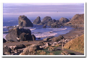
Two miles of cliff and intertidal habitat at Cape Ferrelo, approximately 5 miles north of Brookings, in Curry County, Oregon. |
|
Designation
The beaches and rocky shores of Oregon are part of Oregon’s Ocean Shore Recreation Area and the offshore rocks and islands are part of the Oregon Islands National Wildlife Refuge. |
| |
|
|
Key Resources
Rich and diverse undisturbed intertidal habitat; three small seabird colony sites; harbor seal haulout. |
|
What can you do here?
Low use due to remote location, the lack of access and limited parking, especially to the north end of the site. Most use is restricted to the area near Lone Ranch Beach and includes hiking, tidepooling, beachcombing, sport fishing from shore, surfing and some educational uses. |
Educational Opportunities
There is an interpretive panel at the Lone Ranch Beach day-use parking area that describes the history of the area, including traditional Native American use and history of the Borax mining company.
Getting to the Rocky shore at Cape Ferrelo
There is no direct access to most of the shore in the area. The wayside at Lone Ranch Beach provides shore access (which involves climbing over large rocks) at the south end of the area. Steep, unimproved, locally known trails provide access to some other segments of beach within the area including some from the Cape Ferello viewpoint, which affords limited parking. The Oregon Coast Trail (OCT) fronts the shoreline for much of the length of this site, and provides visual access to several sections to the north, including the House Rock Viewpoint (approximately 1.5 miles from Cape Ferello) and Whaleshead Beach (approximately 3 miles from House Rock). Parking is available at both the Whaleshead Beach and House Rock Viewpoints.
 Public Access Option 1 for Cape Ferrelo Rocky Shore Public Access Option 1 for Cape Ferrelo Rocky Shore
Public Access Option 2 for Cape Ferrelo Rocky Shore
 Public Access Option 3 for Cape Ferrelo Rocky Shore Public Access Option 3 for Cape Ferrelo Rocky Shore
Who Owns this Site?
Submerged and submersible (intertidal) lands: Division of State Lands; offshore rocks above Mean High Water: US Fish and Wildlife Service; adjacent beaches and upland: Oregon Parks and Recreation Department. |
|
Who Manages this Site?
  The upland portion of this site is within Sam Boardman State Scenic Corridor, which is part of OPRD Area 4 (South-Western Oregon) and the Harris Beach Management Unit. The upland portion of this site is within Sam Boardman State Scenic Corridor, which is part of OPRD Area 4 (South-Western Oregon) and the Harris Beach Management Unit. |
|
Data for the Cape Ferrelo Rocky Shore
[1 Records Listed]
Cape Ferrelo Rocky Shore GIS Data |
Data Layer |
Source |
Scale |
Year |
Download |
|
ODOT |
6,000 |
1967 |
|
[1 Records Listed]
Information compiled by Laurel Hillmann, NOAA Coastal Management Fellow, OPRD |