About the Cape Blanco Rocky Shore Area
Description
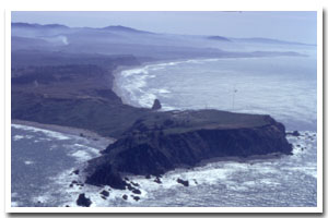
1.4 miles of intertidal and subtidal habitat at the tip of Cape Blanco, approximately 9.5 miles northwest of Port Orford, in Curry County, Oregon |
|
Designation
The beaches and rocky shores of Oregon are part of Oregon’s Ocean Shore Recreation Area and the offshore rocks and islands are part of the Oregon Islands National Wildlife Refuge. |
| |
|
|
Key Resources
Diverse, rich intertidal habitat; harbor seal haulout and pupping areas; rocky subtidal habitat including offshore kelp beds. |
|
What can you do here?
Uses of the area include scientific research, sightseeing, sport fishing from shore, clamming, photography, sightseeing from the lighthouse viewpoint (especially whale watching) and tidepooling. |
Educational Opportunities
An ODFW, “Welcome to Our Home” rocky shore sign is present at the beginning of the path down to the beach on the north end of the site.
Getting to the Rocky shore at Cape Blanco
There is a trail from Cape Blanco State Park on north side with access across the beach on the south side of the headland. Access to the north end of the cape is via a short dirt portion of the Oregon Coast Trail (approximately 0.2 miles) from the Cape Blanco Lighthouse/viewpoint gravel parking area at the end of the Cape Blanco Highway (approximately 5.5 miles west of HWY 101, 5 miles north of Port Orford). Access to the south end of the cape is from the day use parking area south of the campground loop. Instead of following the Cape Blanco Highway to the end, turn left at signs to the campground, drive around the campground loop and follow the sign to the beach. From the beach access parking area it is a approximately 0.9 mile walk across the beach to the beginning of the rocky shore on the south side of Cape Blanco.
 Public Access Option 1 for Cape Blanco Rocky Shore Public Access Option 1 for Cape Blanco Rocky Shore
Who Owns this Site?
Submerged and submersible (intertidal) lands: Division of State
Lands; offshore rocks above Mean High Water: U.S. Fish and Wildlife Service; upland above MHW: Bureau of Land Management; dry sands beach areas and nearby uplands: Oregon Parks and Recreation Department. |
|
Who Manages this Site?
  Upland areas are managed as Cape Blanco State Park. Cape Blanco State Park is part of OPRD Area 4 (South-Western Oregon) and the Cape Blanco Management Unit. Oregon Parks and Recreation Department manages the ocean shore recreation area. Upland areas are managed as Cape Blanco State Park. Cape Blanco State Park is part of OPRD Area 4 (South-Western Oregon) and the Cape Blanco Management Unit. Oregon Parks and Recreation Department manages the ocean shore recreation area. |
|
Data for the Cape Blanco Rocky Shore
[5 Records Listed]
Cape Blanco Rocky Shore GIS Data |
Data Layer |
Source |
Scale |
Year |
Download |
|
NOAA |
736,560 |
1997 |
|
|
NOAA |
191,730 |
1999 |
|
|
USGS |
250,000 |
1981 |
|
|
USGS |
24,000 |
1994 |
|
|
USGS |
24,000 |
1999 |
|
[5 Records Listed]
Information compiled by Laurel Hillmann, NOAA Coastal Management Fellow, OPRD |