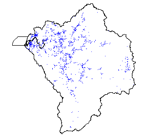
Water Points of Diversion in the Coquille Watershed, 1999
Identification_Information
Data_Quality_Information
Spatial_Data_Organization_Information
Spatial_Reference_Information
Entity_and_Attribute_Information
Distribution_Information
Metadata_Reference_Information
Identification Information
Section Index
Citation:
Citation Information:
Originator: Oregon Water Resources Department
Publication Date: 19990715
Title: Water Points of Diversion in the Coquille Watershed, 1999
Edition: 1999
Geospatial Data Presentation Form: Map
Publication Information:
Publication Place: Salem, Oregon
Publisher: Oregon Water Resources Department
Other Citation Details:
Oregon Water Resources Department (OWRD) water rights (WR) coverages are compiled by theme, places of use (POU) and points of diversion (POD), and are tiled by township, and grouped by OWRD basin. Individual water rights are digitized into a township coverage using the best available base data (public land survey, transportation, and hydrography) for the area in question (1:24,000-scale or larger). Smaller scale base data (1:100,000) have been used in areas where 1:24,000-scale data didn't exist at the time. That should be remedied when the OWRD GIS staff
updates the rights. Conflicts between POU polygons are corrected, as much as possible, by staff to remove overlaps or other errors that may occur from joining individual map layouts. Some conflicts will have to be
corrected after actual ground verification by staff or water rights holders.
Online Linkage: http://www.wrd.state.or.us/
Larger Work Citation:
Citation Information:
Originator: Oregon Water Resources Department
Publication Date: 19990715
Title: Oregon Water Right GIS coverages: Points of Diversion
Publication Information:
Publication Place: Salem, Oregon
Publisher: Oregon Water Resources Department
Online Linkage: http://www.wrd.state.or.us/
Description:
Abstract: Coverage depicts Points of Water Diversion in the Coquille Watershed.
Purpose: The water rights information portrayed in the OWRD GIS
Time Period of Content:
Time Period Information:
Range of Dates/Times:
Beginning Date: 1989
Beginning Time: Unknown
Ending Date: 1999
Ending Time: Unknown
Currentness Reference: 1999
Status:
Progress: In work
Maintenance and Update Frequency: Continually
Spatial Domain:
Bounding Coordinates:
West Bounding Coordinate: -121.001
East Bounding Coordinate: -120.2292
North Bounding Coordinate: 43.3641
South Bounding Coordinate: 42.7566
Keywords:
Theme:
Theme Keyword Thesaurus: None
Theme Keyword: Water Rights
Theme Keyword: Points of Diversion
Theme Keyword: Water use
Place:
Place Keyword Thesaurus: None
Place Keyword: Oregon
Place Keyword: Coquille
Place Keyword: Coast
Access Constraints: None
Use Constraints: The water rights information portrayed in the OWRD GIS
Point of Contact:
Contact Information:
Contact Organization Primary:
Contact Organization: Oregon Water Resources Department
Contact Person: Robert Harmon
Contact Position: GIS Coordinator
Contact Address:
Address Type: mailing and physical address
Address: 158 12th Street NE
City: Salem
State or Province: Oregon
Postal Code: 97310
Country: USA
Contact Voice Telephone: 503-378-8455 x258
Contact Facsimile Telephone: 503-378-2496
Contact Electronic Mail Address: robert.c.harmon@wrd.state.or.us
Native Data Set Environment: Arc/Info coverage format
Data Quality Information
Section Index
Attribute Accuracy:
Attribute Accuracy Report:
Each set of attribute tables for PODs and POUs are related to data tables in Water Rights Information System (WRIS) through an intermediate lookup table In ARC/INFO, relationships between tables are established with the RELATE command. In ArcView, since the nature of the POD/POU attribute table relationship to the lookup and WRIS data tables is
'one-to-many', you should establish a 'link' between the tables. This is described below and you may need to consult your ARC/INFO or ArcView documentation for more information on the RELATE or link command, respectively.
Logical Consistency Report: Point topology present.
Completeness Report:
Digital compilation of the water rights began in 1989 in the northwest portion of the state. Work progressed to the south and then eastward. At this point, approximately 70% of the state has been completed. Only permitted and certificated rights are digitized. Current status is depicted on the OWRD web page at http://www.wrd.state.or.us/maps/status.html Updates began in May 1998 and are carried out on a basin by basin basis. The goal is to have mapped water rights up to date and kept up to date thereafter.
Positional Accuracy:
Horizontal Positional Accuracy:
Horizontal Positional Accuracy Report: Locations shown are only approximate and should not be used in legal, financial, or real estate decisions.
Vertical Positional Accuracy:
Vertical Positional Accuracy Report: NA
Lineage:
Source Information:
Source Citation Abbreviation: POD
Source Contribution: Points and attributes
Process Step:
Process Description: The POD coverage was downloaded and clipped to the Watershed boundary.
Source Used Citation Abbreviation: POD
Process Date: 1999
Cloud Cover: 0
Spatial Data Organization Information
Section Index
Direct Spatial Reference Method: Point
Point and Vector Object Information:
SDTS Terms Description:
SDTS Point and Vector Object Type: Point
Point and Vector Object Count: 1730
Spatial Reference Information
Section Index
Horizontal Coordinate System Definition:
Planar:
Map Projection:
Map Projection Name: Lambert Conformal Conic
Lambert Conformal Conic:
Standard Parallel: 43
Standard Parallel: 45.5
Longitude of Central Meridian: -120.5
Latitude of Projection Origin: 41.75
False Easting: 400000
False Northing: 0
Planar Coordinate Information:
Planar Coordinate Encoding Method: Coordinate Pair
Coordinate Representation:
Abscissa Resolution: 0
Ordinate Resolution: 0
Planar Distance Units: international feet
Geodetic Model:
Horizontal Datum Name: North American Datum of 1983
Ellipsoid Name: Geodetic Reference System 80
Semi-major Axis: 6378137
Denominator of Flattening Ratio: 298.257
Entity and Attribute Information
Section Index
Detailed Description:
Entity Type:
Entity Type Label: waterpod.pat
Entity Type Definition: Point Attribute Table
Entity Type Definition Source: None
Attribute:
Attribute Label: Area
Attribute Definition: Area of polygon
Attribute Definition Source: Software generated
Attribute Domain Values:
Unrepresentable Domain: Software computed
Attribute:
Attribute Label: Mapname
Attribute Definition: Map Name from which POD was digitized
Attribute Domain Values:
Unrepresentable Domain: Character Field
Attribute:
Attribute Label: Perimeter
Attribute Definition: Perimeter of polygon
Attribute Definition Source: Software generated
Attribute Domain Values:
Unrepresentable Domain: Software computed
Attribute:
Attribute Label: Pod_id
Attribute Definition: Point of Diversion ID
Attribute Domain Values:
Range Domain:
Range Domain Minimum: 0
Range Domain Maximum: 363
Attribute:
Attribute Label: Pod_relate
Attribute Definition: Unique relate field which links items to WRIS look-up table
Attribute Definition Source: WRD
Attribute Domain Values:
Unrepresentable Domain: Character Field (a combination of integer ID and Mapname).
Attribute:
Attribute Label: Waterpod#
Attribute Definition: Internal feature number
Attribute Definition Source: Software generated
Attribute Domain Values:
Unrepresentable Domain: Software computed
Attribute:
Attribute Label: Waterpod-id
Attribute Definition: Feature identification number
Attribute Definition Source: Software generated
Attribute Domain Values:
Unrepresentable Domain: User Defined
Distribution Information
Section Index
Distributor:
Contact Information:
Contact Organization Primary:
Contact Organization: Oregon Water Resources Department
Contact Person: Robert Harmon
Contact Position: GIS Coordinator
Contact Address:
Address Type: mailing and physical address
Address: 158 12th Street NE
City: Salem
State or Province: Oregon
Postal Code: 97310
Country: USA
Contact Voice Telephone: 503-378-8455 x258
Contact Facsimile Telephone: 503-378-2496
Contact Electronic Mail Address: robert.c.harmon@wrd.state.or.us
Resource Description: POD
Distribution Liability:
The water rights information portrayed in the OWRD GIS themes have been interpreted by the Department's staff from information in the Department's files and are intended to represent that interpretation
graphically. Locations shown are only approximate and should not be used in legal, financial, or real estate decisions. For more accurate legal location
information, please contact the Department. It is strongly recommended that if you have any questions concerning individual water rights that you contact your local watermaster or the water rights staff at the Oregon Water Resources Department.
THE DATA AND ASSOCIATED DATA FILES ON THIS CD-ROM ARE
PROVIDED ""AS IS,"" WITHOUT WARRANTY TO THEIR PERFORMANCE, MERCHANTABLE STATE, OR FITNESS FOR ANY PARTICULAR PURPOSE. THE ENTI RE RISK ASSOCIATED WITH THE RESULTS AND PERFORMANCES OF THE DATA IS ASSUMED
BY THE USER. THIS DATA IS NOT FOR NAVIGATIONAL OR LEGAL PURPOSES.
Custom Order Process: Contact distributor or download from: http://www.wrd.state.or.us/maps/wrexport.html
Available Time Period:
Metadata Reference Information
Section Index
Metadata Date: 1/1/2000
Metadata Review Date:
Metadata Future Review Date:
Metadata Contact:
Contact Information:
Contact Organization Primary:
Contact Organization:
Oregon Ocean Coastal Management Program - Department of
Land Conservation and Development
Contact Person: Tanya Haddad
Contact Position: DEMIS Coordinator
Contact Address:
Address Type: mailing and physical address
Address: 800 NE Oregon Street #18
City: Portland
State or Province: Oregon
Postal Code: 97232
Country: USA
Contact Voice Telephone: 503-731-4065 x30
Contact Facsimile Telephone: 503-731-4068
Contact Electronic Mail Address: tanya.haddad@state.or.us
Metadata Standard Name: FGDC CSDGM
Metadata Standard Version: FGDC-STD-001-1998
SMMS Metadata report generated 3/27/2002