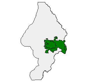
Late Successional Old Growth Boundaries in the Sixes Watershed, FEMAT, 1994
Identification_Information
Spatial_Data_Organization_Information
Spatial_Reference_Information
Entity_and_Attribute_Information
Distribution_Information
Metadata_Reference_Information
Identification Information
Section Index
Citation:
Citation Information:
Originator: Jeanne Keyes--Data Steward,Dale Guenther--Procedural Contact
Publication Date: Unpublished Material
Title: Late Successional Old Growth Boundaries in the Sixes Watershed, FEMAT, 1994
Geospatial Data Presentation Form: vector digital data
Online Linkage: http://www.reo.gov/gis/data/gisdata/index.htm
Description:
Abstract: Late Successional Old Growth
Purpose: Late Successional Old Growth boundaries developed by Forest Ecosystem Management Assessment Team , REO
Supplemental Information:
20040226 For purposes of Oregon Coastal Atlas project this data was reprojected and clipped to Sixes basin boundaries. Please refer to originators for original data and further information regarding this data.
Time Period of Content:
Time Period Information:
Single Date/Time:
Calendar Date: 7/3/1993
Time of Day: Unknown
Currentness Reference: publication date
Status:
Progress: Complete
Maintenance and Update Frequency: Unknown
Spatial Domain:
Bounding Coordinates:
West Bounding Coordinate: -124.703537
East Bounding Coordinate: -124.134727
North Bounding Coordinate: 43.122093
South Bounding Coordinate: 42.415104
Keywords:
Theme:
Theme Keyword Thesaurus: None
Theme Keyword: Owl
Theme Keyword: boundary
Place:
Place Keyword Thesaurus: None
Place Keyword: Oregon
Place Keyword: Sixes
Access Constraints: none
Use Constraints: none
Native Data Set Environment: Microsoft Windows 2000 Version 5.0 (Build 2195) Service Pack 4; ESRI ArcCatalog 8.3.0.800
Spatial Data Organization Information
Section Index
Direct Spatial Reference Method: Vector
Point and Vector Object Information:
SDTS Terms Description:
SDTS Point and Vector Object Type: Complete chain
Point and Vector Object Count: 5941
SDTS Terms Description:
SDTS Point and Vector Object Type: Label point
Point and Vector Object Count: 3236
SDTS Terms Description:
SDTS Point and Vector Object Type: GT-polygon composed of chains
Point and Vector Object Count: 3235
SDTS Terms Description:
SDTS Point and Vector Object Type: Point
Point and Vector Object Count: 28
Spatial Reference Information
Section Index
Horizontal Coordinate System Definition:
Planar:
Map Projection:
Map Projection Name: Lambert Conformal Conic
Lambert Conformal Conic:
Standard Parallel: 43
Standard Parallel: 45.5
Longitude of Central Meridian: -120.5
Latitude of Projection Origin: 41.75
False Easting: 400000
False Northing: 0
Planar Coordinate Information:
Planar Coordinate Encoding Method: Coordinate Pair
Coordinate Representation:
Abscissa Resolution: 0.035372
Ordinate Resolution: 0.035372
Planar Distance Units: international feet
Geodetic Model:
Horizontal Datum Name: North American Datum of 1983
Ellipsoid Name: Geodetic Reference System 80
Semi-major Axis: 6378137
Denominator of Flattening Ratio: 298.257
Entity and Attribute Information
Section Index
Detailed Description:
Entity Type:
Entity Type Label: lsog_194.pat
Entity Type Definition: Polygon attribute table
Entity Type Definition Source: ArcInfo 7.2.1
Attribute:
Attribute Label: AREA
Attribute Definition: Area of feature in internal units squared.
Attribute Definition Source: ESRI
Attribute Domain Values:
Unrepresentable Domain: Positive real numbers that are automatically generated.
Attribute:
Attribute Label: FID
Attribute Definition: Internal feature number.
Attribute Definition Source: ESRI
Attribute Domain Values:
Unrepresentable Domain: Sequential unique whole numbers that are automatically generated.
Attribute:
Attribute Label: LSOG
Attribute Definition: LATE SUCCESSIONAL OLD GROWTH
Attribute Definition Source: REO
Attribute Domain Values:
Enumerated Domain:
Enumerated Domain Value: 0
Enumerated Domain Value Definition: OUT
Enumerated Domain Value Definition Source: REO
Enumerated Domain:
Enumerated Domain Value: 1
Enumerated Domain Value Definition: OG1
Enumerated Domain Value Definition Source: REO
Enumerated Domain:
Enumerated Domain Value: 2
Enumerated Domain Value Definition: OG2
Enumerated Domain Value Definition Source: REO
Enumerated Domain:
Enumerated Domain Value: 3
Enumerated Domain Value Definition: OADD
Enumerated Domain Value Definition Source: REO
Enumerated Domain:
Enumerated Domain Value: 4
Enumerated Domain Value Definition: OAD2
Enumerated Domain Value Definition Source: REO
Enumerated Domain:
Enumerated Domain Value: 5
Enumerated Domain Value Definition: OAD1
Enumerated Domain Value Definition Source: REO
Attribute:
Attribute Label: LSOG_194#
Attribute Definition: Internal feature number.
Attribute Definition Source: ESRI
Attribute Domain Values:
Unrepresentable Domain: Sequential unique whole numbers that are automatically generated.
Attribute:
Attribute Label: LSOG_194-ID
Attribute Definition: User-defined feature number.
Attribute Definition Source: ESRI
Attribute Domain Values:
Unrepresentable Domain: ID
Attribute:
Attribute Label: LSOGG1
Attribute Definition: UNIQUE # FOR GROUPS OG1
Attribute Definition Source: REO
Attribute Domain Values:
Unrepresentable Domain: NNN
Attribute:
Attribute Label: LSOGG12A
Attribute Definition: UNIQUE # FOR GROUPS OG1 + OG2 + OADD
Attribute Definition Source: REO
Attribute Domain Values:
Unrepresentable Domain: NNN
Attribute:
Attribute Label: LSOGG1A
Attribute Definition: UNIQUE # FOR GROUPS OG1 + OADD
Attribute Definition Source: REO
Attribute Domain Values:
Unrepresentable Domain: NNN
Attribute:
Attribute Label: LSOGG1D
Attribute Definition: UNIQUE FOR GROUPS OG2 = DCA
Attribute Definition Source: REO
Attribute Domain Values:
Unrepresentable Domain: NNN
Attribute:
Attribute Label: LSOGG2A
Attribute Definition: UNIQUE # FOR GROUPS OG2 + OADD
Attribute Definition Source: REO
Attribute Domain Values:
Unrepresentable Domain: NNN
Attribute:
Attribute Label: PERIMETER
Attribute Definition: Perimeter of feature in internal units.
Attribute Definition Source: ESRI
Attribute Domain Values:
Unrepresentable Domain: Positive real numbers that are automatically generated.
Attribute:
Attribute Label: Shape
Attribute Definition: Feature geometry.
Attribute Definition Source: ESRI
Attribute Domain Values:
Unrepresentable Domain: Coordinates defining the features.
Distribution Information
Section Index
Distributor:
Contact Information:
Contact Person Primary:
Contact Person: Jeanne Keyes
Contact Organization: Regional Ecosystem Office
Contact Position: Procedural Contact
Contact Address:
Address Type: mailing and physical address
Address: 333 SW First Avenue, P.O. Box 3623
City: Portland
State or Province: OR
Postal Code: 97208-3623
Country: USA
Contact Voice Telephone: 503.808.2187
Hours of Service: 8 am - 5 pm
Resource Description: Sixes Late Successional Old Growth
Distribution Liability:
Ecotrust makes no express or implied warrantees with respect to
the character, fitness, or accuracy of the information presented,
or their appropriateness for any users purposes.
Standard Order Process:
Digital Form:
Digital Transfer Information:
Format Name: Compressed E00
Format Version Number: 7.2.1
File Decompression Technique: Unzip or pkunzip
Transfer Size: 38.072
Digital Transfer Option:
Online Option:
Computer Contact Information:
Network Address:
Network Resource Name: http://www.reo.gov/gis/data/gisdata/index.htm
Access Instructions: Anonymous FTP
Fees: None
Ordering Instructions: Obtain data at http://www.reo.gov/gis/data/gisdata/index.htm
Turnaround: Less than 1 hour
Available Time Period:
Time Period Information:
Single Date/Time:
Calendar Date: Unknown
Time of Day: Unknown
Metadata Reference Information
Section Index
Metadata Date: 3/1/2004
Metadata Review Date:
Metadata Future Review Date:
Metadata Contact:
Contact Information:
Contact Organization Primary:
Contact Organization: Ecotrust
Contact Address:
Address Type: mailing address
Address: 721 NW 9th Suite 200
City: Portland
State or Province: Oregon
Postal Code: 97209
Country: USA
Contact Voice Telephone: 503-227-6225
Contact Instructions: Ecotrust created FGDC metadata from the originator's metadata so we can serve the GIS information. Please refer back to the originator for updates and additional information or clarification.
Metadata Standard Name: FGDC Content Standards for Digital Geospatial Metadata
Metadata Standard Version: FGDC-STD-001-1998
Metadata Time Convention: local time
Metadata Extensions:
Online Linkage: http://www.esri.com/metadata/esriprof80.html
Profile Name: ESRI Metadata Profile
SMMS Metadata report generated 6/9/2005