Key Watersheds in the Sixes Hydrologic Unit, Northwest Forest Plan, 1993
Identification_Information
Data_Quality_Information
Spatial_Data_Organization_Information
Spatial_Reference_Information
Entity_and_Attribute_Information
Distribution_Information
Metadata_Reference_Information
Identification Information
Section Index
Citation:
Citation Information:
Originator: Regional Ecosystem Office
Publication Date: 19930703
Title: Key Watersheds in the Sixes Hydrologic Unit, Northwest Forest Plan, 1993
Geospatial Data Presentation Form: vector digital data
Online Linkage: http://www.reo.gov/gis/data/gisdata/index.htm
Description:
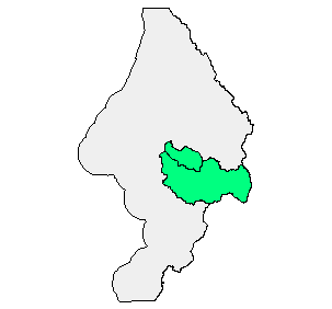
Abstract: Key Watersheds identified in the NFP as important for maintaining and recovering habitat for at-risk fish speciesas determined by the Owl Range Managment Assessment Team 1993.
Purpose: Record of Identified Key Watersheds
Supplemental Information:
Manuscripts made from mylar overlays of 1:126720, but maps. Accuracy should be classified as minimal, but acceptable. Manuscripts digitized and scanned.
20040226 For purposes of Oregon Coastal Atlas project this data was reprojected and clipped to Sixes basin boundaries. Please refer to originators for original data and further information regarding this data.
Time Period of Content:
Time Period Information:
Single Date/Time:
Calendar Date: Unknown
Time of Day: Unknown
Currentness Reference: unknown
Status:
Progress: Complete
Maintenance and Update Frequency: Unknown
Spatial Domain:
Bounding Coordinates:
West Bounding Coordinate: -124.703537
East Bounding Coordinate: -124.134727
North Bounding Coordinate: 43.122093
South Bounding Coordinate: 42.415104
Keywords:
Theme:
Theme Keyword Thesaurus: None
Theme Keyword: watershed
Theme Keyword: owl
Theme Keyword: boundary
Place:
Place Keyword Thesaurus: None
Place Keyword: Oregon
Place Keyword: Sixes
Access Constraints: none
Use Constraints: none
Point of Contact:
Contact Information:
Contact Person Primary:
Contact Person: Robert Varner
Contact Organization: Regional Ecosystem O
Contact Position: Procedural Contact
Contact Address:
Address Type: mailing and physical address
Address: 333 SW First Avenue, P.O. Box 3623
City: Portland
State or Province: OR
Postal Code: 97208-3623
Country: USA
Contact Voice Telephone: 503.808.2128
Native Data Set Environment: Microsoft Windows 2000 Version 5.0 (Build 2195) Service Pack 4; ESRI ArcCatalog 8.3.0.800
Data Quality Information
Section Index
Attribute Accuracy:
Attribute Accuracy Report: See http://www.reo.gov/gis/data/gisdata/index.htm
Logical Consistency Report: Polygon topology
Completeness Report: No exclusions, datasets complete to 1993 priorities.
Lineage:
Source Information:
Source Citation:
Citation Information:
Originator: Regional Ecosystem Office
Publication Date: 19930703
Title: Key Watersheds in the Sixes Hydrologic Unit, Northwest Forest Plan, 1993
Geospatial Data Presentation Form: vector digital data
Online Linkage: http://www.reo.gov/gis/data/gisdata/index.htm
Source Time Period of Content:
Source Citation Abbreviation: k_sheds
Source Contribution:
Record of Identified Key Watersheds. Key Watersheds were identified in the NFP as important for maintaining and recovering habitat for at-risk fish speciesas determined by the Owl Range Managment Assessment Team 1993.
Process Step:
Process Description: Manuscripts made from mylar overlays of 1:126720, but maps. Accuracy should be classified as minimal, but acceptable
Process Date: 19930703
Cloud Cover: 0
Spatial Data Organization Information
Section Index
Direct Spatial Reference Method: Vector
Point and Vector Object Information:
SDTS Terms Description:
SDTS Point and Vector Object Type: Complete chain
Point and Vector Object Count: 1003
SDTS Terms Description:
SDTS Point and Vector Object Type: Label point
Point and Vector Object Count: 276
SDTS Terms Description:
SDTS Point and Vector Object Type: GT-polygon composed of chains
Point and Vector Object Count: 276
SDTS Terms Description:
SDTS Point and Vector Object Type: Point
Point and Vector Object Count: 263
Spatial Reference Information
Section Index
Horizontal Coordinate System Definition:
Planar:
Map Projection:
Map Projection Name: Lambert Conformal Conic
Lambert Conformal Conic:
Standard Parallel: 43
Standard Parallel: 45.5
Longitude of Central Meridian: -120.5
Latitude of Projection Origin: 41.75
False Easting: 400000
False Northing: 0
Planar Coordinate Information:
Planar Coordinate Encoding Method: Coordinate Pair
Coordinate Representation:
Abscissa Resolution: 0.008192
Ordinate Resolution: 0.008192
Planar Distance Units: international feet
Geodetic Model:
Horizontal Datum Name: North American Datum of 1983
Ellipsoid Name: Geodetic Reference System 80
Semi-major Axis: 6378137
Denominator of Flattening Ratio: 298.257
Entity and Attribute Information
Section Index
Detailed Description:
Entity Type:
Entity Type Label: k_shed.aat
Entity Type Definition: Arc attribute table
Entity Type Definition Source: ArcInfo 7.2.1
Attribute:
Attribute Label: FID
Attribute Definition: Internal feature number.
Attribute Definition Source: ESRI
Attribute Domain Values:
Unrepresentable Domain: Sequential unique whole numbers that are automatically generated.
Attribute:
Attribute Label: FNODE#
Attribute Definition: Internal node number for the beginning of an arc (from-node).
Attribute Definition Source: ESRI
Attribute Domain Values:
Unrepresentable Domain: Whole numbers that are automatically generated.
Attribute:
Attribute Label: K_SHED#
Attribute Definition: Internal feature number.
Attribute Definition Source: ESRI
Attribute Domain Values:
Unrepresentable Domain: Sequential unique whole numbers that are automatically generated.
Attribute:
Attribute Label: K_SHED-ID
Attribute Definition: User-defined feature number.
Attribute Definition Source: ESRI
Attribute Domain Values:
Unrepresentable Domain: ID
Attribute:
Attribute Label: LENGTH
Attribute Definition: Length of feature in internal units.
Attribute Definition Source: ESRI
Attribute Domain Values:
Unrepresentable Domain: Positive real numbers that are automatically generated.
Attribute:
Attribute Label: LPOLY#
Attribute Definition: Internal node number for the left polygon.
Attribute Definition Source: ESRI
Attribute Domain Values:
Unrepresentable Domain: Whole numbers that are automatically generated.
Attribute:
Attribute Label: RPOLY#
Attribute Definition: Internal node number for the right polygon.
Attribute Definition Source: ESRI
Attribute Domain Values:
Unrepresentable Domain: Whole numbers that are automatically generated.
Attribute:
Attribute Label: Shape
Attribute Definition: Feature geometry.
Attribute Definition Source: ESRI
Attribute Domain Values:
Unrepresentable Domain: Coordinates defining the features.
Attribute:
Attribute Label: TNODE#
Attribute Definition: Internal node number for the end of an arc (to-node).
Attribute Definition Source: ESRI
Attribute Domain Values:
Unrepresentable Domain: Whole numbers that are automatically generated.
Detailed Description:
Entity Type:
Entity Type Label: k_shed.pat
Entity Type Definition: Polygon attribute table
Entity Type Definition Source: ArcInfo 7.2.1
Attribute:
Attribute Label: AREA
Attribute Definition: Area of feature in internal units squared.
Attribute Definition Source: ESRI
Attribute Domain Values:
Unrepresentable Domain: Positive real numbers that are automatically generated.
Attribute:
Attribute Label: FID
Attribute Definition: Internal feature number.
Attribute Definition Source: ESRI
Attribute Domain Values:
Unrepresentable Domain: Sequential unique whole numbers that are automatically generated.
Attribute:
Attribute Label: K_SHED#
Attribute Definition: Internal feature number.
Attribute Definition Source: ESRI
Attribute Domain Values:
Unrepresentable Domain: Sequential unique whole numbers that are automatically generated.
Attribute:
Attribute Label: K_SHED-ID
Attribute Definition: User-defined feature number.
Attribute Definition Source: ESRI
Attribute Domain Values:
Unrepresentable Domain: ID
Attribute:
Attribute Label: KWS_ACRES
Attribute Definition: KEY WATERSHED Area in GIS ACRES
Attribute Definition Source: REO
Attribute Domain Values:
Unrepresentable Domain: ACRES
Attribute:
Attribute Label: KWS_DASH
Attribute Definition Source: REO
Attribute:
Attribute Label: KWS_ID
Attribute Definition: DATABASE CODE
Attribute Definition Source: REO
Attribute Domain Values:
Enumerated Domain:
Enumerated Domain Value: C
Enumerated Domain Value Definition: CALIFORNIA
Enumerated Domain Value Definition Source: REO
Enumerated Domain:
Enumerated Domain Value: O
Enumerated Domain Value Definition: OREGON
Enumerated Domain Value Definition Source: REO
Enumerated Domain:
Enumerated Domain Value: W
Enumerated Domain Value Definition: WASHINGTON
Enumerated Domain Value Definition Source: REO
Enumerated Domain:
Enumerated Domain Value: F
Enumerated Domain Value Definition: FISH (SPECIES LISTED IN GANG REPORT, APP D)
Enumerated Domain Value Definition Source: REO
Enumerated Domain:
Enumerated Domain Value: -
Enumerated Domain Value Definition: DASH SEPARATOR
Enumerated Domain Value Definition Source: REO
Enumerated Domain:
Enumerated Domain Value: NN
Enumerated Domain Value Definition: SYSTEM GENERATED NUMBER
Enumerated Domain Value Definition Source: REO
Attribute:
Attribute Label: KWS_NAME
Attribute Definition: KEY WATERSHED NAME (LISTED IN FEMAT V-H)
Attribute Definition Source: REO
Attribute Domain Values:
Unrepresentable Domain: Name
Attribute:
Attribute Label: KWS_NUM
Attribute Definition Source: REO
Attribute:
Attribute Label: KWS_STAT
Attribute Definition Source: REO
Attribute:
Attribute Label: KWS_TIER
Attribute Definition: KEY WATERSHED TEIR
Attribute Definition Source: REO
Attribute Domain Values:
Enumerated Domain:
Enumerated Domain Value: 1
Enumerated Domain Value Definition: TIER 1 KEY WATERSHED
Enumerated Domain Value Definition Source: REO
Enumerated Domain:
Enumerated Domain Value: 2
Enumerated Domain Value Definition: TIER 2 KEY WATERSHED
Enumerated Domain Value Definition Source: REO
Attribute:
Attribute Label: PERIMETER
Attribute Definition: Perimeter of feature in internal units.
Attribute Definition Source: ESRI
Attribute Domain Values:
Unrepresentable Domain: Positive real numbers that are automatically generated.
Attribute:
Attribute Label: Shape
Attribute Definition: Feature geometry.
Attribute Definition Source: ESRI
Attribute Domain Values:
Unrepresentable Domain: Coordinates defining the features.
Distribution Information
Section Index
Distributor:
Contact Information:
Contact Person Primary:
Contact Person: Robert Varner
Contact Organization: Regional Ecosystem Office
Contact Position: Procedural Contact
Contact Address:
Address Type: mailing and physical address
Address: 333 SW First Avenue, P.O. Box 3623
City: Portland
State or Province: OR
Postal Code: 97208-3623
Country: USA
Contact Voice Telephone: 503.808.2128
Hours of Service: 8 am - 5 pm
Resource Description: Sixes key watershed
Distribution Liability:
Ecotrust makes no express or implied warrantees with respect to
the character, fitness, or accuracy of the information presented,
or their appropriateness for any users purposes.
Standard Order Process:
Digital Form:
Digital Transfer Information:
Format Name: Compressed E00
Format Version Number: 7.2.1
File Decompression Technique: Unzip or pkunzip
Transfer Size: 38.072
Digital Transfer Option:
Online Option:
Computer Contact Information:
Network Address:
Network Resource Name: http://www.reo.gov/gis/data/gisdata/index.htm
Access Instructions: Anonymous FTP
Fees: None
Ordering Instructions: Obtain data at http://www.reo.gov/gis/data/gisdata/index.htm
Turnaround: Less than 1 hour
Available Time Period:
Time Period Information:
Single Date/Time:
Calendar Date: 2003
Time of Day: Unknown
Metadata Reference Information
Section Index
Metadata Date: 2/27/2004
Metadata Review Date:
Metadata Future Review Date:
Metadata Contact:
Contact Information:
Contact Organization Primary:
Contact Organization: Ecotrust
Contact Address:
Address Type: mailing address
Address: 721 NW 9th Suite 200
City: Portland
State or Province: Oregon
Postal Code: 97209
Country: USA
Contact Voice Telephone: 503-227-6225
Contact Instructions: Ecotrust created FGDC metadata from the originator's metadata so we can serve the GIS information. Please refer back to the originator for updates and additional information or clarification.
Metadata Standard Name: FGDC Content Standards for Digital Geospatial Metadata
Metadata Standard Version: FGDC-STD-001-1998
Metadata Time Convention: local time
Metadata Extensions:
Online Linkage: http://www.esri.com/metadata/esriprof80.html
Profile Name: ESRI Metadata Profile
SMMS Metadata report generated 6/9/2005