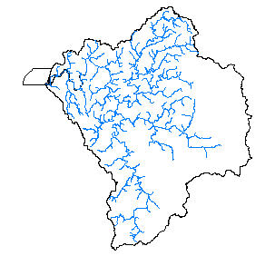
Coho Salmon Distribution for the Coquille Basin, 1998
Identification_Information
Data_Quality_Information
Spatial_Data_Organization_Information
Spatial_Reference_Information
Distribution_Information
Metadata_Reference_Information
Identification Information
Section Index
Citation:
Citation Information:
Originator: Oregon Department of Fish and Wildlife, Keith Hupperts
Publication Date: 1999
Title: Coho Salmon Distribution for the Coquille Basin, 1998
Edition: 1998
Geospatial Data Presentation Form: Map
Publication Information:
Publication Place: Salem, Oregon
Publisher: Oregon Department of Fish and Wildlife
Online Linkage: http://www.odfw.state.or.us
Larger Work Citation:
Description:
Abstract:
Distribution of Coho. This is a DYNAMIC dataset in that it represents stream segments that are known to be used by Coho. However, these reaches may not be used on an annual basis due to natural variations in run size, water conditions and other environmental factors.
Purpose: To map known distribution of Coho salmon.
Supplemental Information:
This data was created through a process where 1:100,000 scale hardcopy maps were plotted by hydrologic unit and then provided to ODFW field staff. Based on survey data, supporting documentation and the best professional judgement of
field biologists, the distribution of spawning, rearing and migration use types were then marked on the maps with highlighter pens.
This data was then digitized by ODFW GIS staff and stored as event tables in Info file format. For mapping purposes, using the tools of dynamic segmentation, the event tables are combined with the 1:100,000 scale routed streams coverages
on a HUC by HUC basis. For the purpose of distributing this data, we have converted the event tables into coverage format with the EVENTARC command.This results in a static version of the "dynamic" data, but in a more common format.
Time Period of Content:
Time Period Information:
Range of Dates/Times:
Beginning Date:
Beginning Time: Unknown
Ending Date: 1998
Ending Time: Unknown
Currentness Reference: Current plans are to update this data every 2 years.
Status:
Progress: In work
Maintenance and Update Frequency: 2 years
Spatial Domain:
Bounding Coordinates:
West Bounding Coordinate: -120.0108
East Bounding Coordinate: -119.3332
North Bounding Coordinate: 43.3965
South Bounding Coordinate: 42.7452
Keywords:
Theme:
Theme Keyword Thesaurus: None
Theme Keyword: Estuary
Theme Keyword: Salmon
Place:
Place Keyword Thesaurus: None
Place Keyword: Oregon
Place Keyword: Coquille
Place Keyword: Oregon Coast
Access Constraints: None
Use Constraints: Many streams that contain Coho distribution are not found in the 1:100,000 scale streams data.
Point of Contact:
Contact Information:
Contact Organization Primary:
Contact Organization: Oregon Department of Fish and Wildlife
Contact Person: Keith Hupperts
Contact Address:
Address Type: mailing and physical address
Address: 2501 SW Fist Ave, PO Box 59
City: Portland
State or Province: Oregon
Postal Code: 97207
Country: USA
Native Data Set Environment: Arc/Info coverage format
Data Quality Information
Section Index
Attribute Accuracy:
Attribute Accuracy Report: Attribute accuracy is described, where present, with each attribute defined in the Entity and Attribute Section.
Logical Consistency Report: Chain-node topology present.
Completeness Report: All distribution data have been reviewed at least once by the ODFW Field staff (typically District Biologists), however, some of this data may have changed due to its dynamic nature.
Positional Accuracy:
Vertical Positional Accuracy:
Vertical Positional Accuracy Report: NA
Lineage:
Source Information:
Source Citation:
Citation Information:
Originator: Oregon Department of Fish and Wildlife
Publication Date: 1999
Title: Coho Salmon Distribution
Edition: 1998
Geospatial Data Presentation Form: map
Publication Information:
Publication Place: Salem, Oregon
Publisher: Oregon Department of Fish and Wildlife
Online Linkage: http://www.odfw.state.or.us
Larger Work Citation:
Source Time Period of Content:
Time Period Information:
Range of Dates/Times:
Beginning Date:
Beginning Time: Unknown
Ending Date: 1998
Ending Time: Unknown
Source Currentness Reference: Data will be updated every two years
Source Citation Abbreviation: Coho
Process Step:
Process Description:
Down loaded .e00 files, unzipped, and clipped to DEMIS Coquille Basin boundary coverage (""donut""). ODFW processes
as follows:
Cloud Cover: 0
Spatial Data Organization Information
Section Index
Direct Spatial Reference Method: Vector
Spatial Reference Information
Section Index
Horizontal Coordinate System Definition:
Planar:
Map Projection:
Map Projection Name: Lambert Conformal Conic
Lambert Conformal Conic:
Standard Parallel: 43
Standard Parallel: 45.5
Longitude of Central Meridian: -120.5
Latitude of Projection Origin: 41.75
False Easting: 400000
False Northing: 0
Planar Coordinate Information:
Planar Coordinate Encoding Method: Coordinate Pair
Coordinate Representation:
Abscissa Resolution: 0
Ordinate Resolution: 0
Planar Distance Units: international feet
Geodetic Model:
Horizontal Datum Name: North American Datum of 1983
Ellipsoid Name: Geodetic Reference System 80
Semi-major Axis: 6378137
Denominator of Flattening Ratio: 298.257
Distribution Information
Section Index
Distributor:
Contact Information:
Contact Organization Primary:
Contact Organization: Oregon Ocean Coastal Management Program
Contact Person: Coastal GIS Coordinator
Contact Position: Coastal GIS Coordinator
Contact Address:
Address Type: mailing address
Address: 800 NE Oregon St #18
City: Portland
State or Province: OR
Postal Code: 97232
Country: USA
Contact Voice Telephone: 503-731-4065 x31
Contact Facsimile Telephone: 503-731-4068
Contact Electronic Mail Address: randy.dana@state.or.us
Metadata Reference Information
Section Index
Metadata Date:
Metadata Review Date:
Metadata Future Review Date:
Metadata Contact:
Contact Information:
Contact Organization Primary:
Contact Organization:
Oregon Ocean Coastal Management Program - Department of
Land Conservation and Development
Contact Person: Tanya Haddad
Contact Position: DEMIS Coordinator
Contact Address:
Address Type: mailing and physical address
Address: 800 NE Oregon Street #18
City: Portland
State or Province: Oregon
Postal Code: 97232
Country: USA
Contact Voice Telephone: 503-731-4065 x30
Contact Facsimile Telephone: 503-731-4068
Contact Electronic Mail Address: tanya.haddad@state.or.us
SMMS Metadata report generated 3/26/2002