About the Harts Cove at Cascade Head Rocky Shore Area
Description
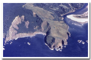
2.4 miles of steep, isolated cliffs, rocky intertidal, and offshore rocks at Harts Cove, Cliff Creek Cove, and some surrounding areas on Cascade Head. This area is located off of a forest service road (1861), which is located west of HWY 101, approximately 3.5 miles north of the Salmon River Estuary and the junction with HWY 18 in Tillamook County, Oregon. Two Arches Rock and other small rocks lie just offshore from the base of the cliffs. |
|
Designation
The intertidal site is not specially designated, however, much of the upland property is managed by USDA-Forest Service as the Neskowin Crest Research Natural Area. |
| |
|
|
Key Resources
Seabird colonies with over 15,000 birds total (common murre; double-crested, pelagic, and Brandt's cormorant; pigeon guillemot; western gull; tufted puffin; rhinoceros auklet; black oystercatcher; peregrine falcon); large mammal haulout area on the beach of the two coves for Steller and California sea lions and harbor seals; threatened and endangered species (Steller sea lion, brown pelican, bald eagle). The isolation of the area is itself a valuable resource. |
|
What can you do here?
Human use of the area is primarily the surrounding uplands with some hikers into Harts Cove to fish or sightsee; use of Cliff Creek Cove is minimal due to poor access. For a map of the FS trail system at cascade head see this link. |
Getting to the Rocky shore at Harts Cove at Cascade Head
There is an access trail to upland areas near Harts Cove with no improved access into Cliff Creek Cove or other portions of shoreline. Access to a portion of the site is via forest service road 1861, off of HWY 101. For a map of the FS trail system at cascade head see this link. The road is approximately 4 miles, and at one point forks (at which point bear left) and ends in a small parking area for the Harts Cove trail. This road is closed from January 15th to June 16th. From the parking area, the trail winds down for 2.7 miles to a grassy field. There is no access to most of the shore level, but visual access to Harts Cove is afforded by walking around the open area on a variety of unofficial trails.
 Public Access Option 1 for Harts Cove at Cascade Head Rocky Shore Public Access Option 1 for Harts Cove at Cascade Head Rocky Shore
Who Owns this Site?
Submerged and intertidal lands: Division of State Lands; beach: Oregon Parks and Recreation Department; offshore rocks above MHW: the US Fish and Wildlife Service; upland adjacent to the coves: U.S. Forest Service; Nature Conservancy lands abut to the south. |
|
Who Manages this Site?
 The adjacent upland is managed by the USDA Forest Service as Cascade Head/Neskowin Crest Research Natural Area. For a map of the FS trail system at cascade head see this link. The adjacent upland is managed by the USDA Forest Service as Cascade Head/Neskowin Crest Research Natural Area. For a map of the FS trail system at cascade head see this link. |
|
Data for the Harts Cove at Cascade Head Rocky Shore
[5 Records Listed]
Harts Cove at Cascade Head Rocky Shore GIS Data |
Data Layer |
Source |
Scale |
Year |
Download |
|
ODOT |
6,000 |
1967 |
|
|
ODFW |
24,000 |
2010 |
|
|
ODFW |
24,000 |
2010 |
|
|
ODFW |
24,000 |
2010 |
|
|
ODFW |
24,000 |
2010 |
|
[5 Records Listed]
Information compiled by Laurel Hillmann, NOAA Coastal Management Fellow, OPRD |