About the Tillamook Head Rocky Shore Area
Description
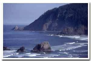
Approximately 4 miles of cliffs, rocky intertidal, and nearshore rocks at the tip of Tillamook Head. The site is located to the north of the Ecola State Park, Indian Beach parking area (the second parking lot in the park), which is approximately 10 minutes driving distance from downtown Cannon Beach, Oregon. |
|
Designation
The beaches and rocky shores of Oregon are part of Oregon’s Ocean Shore Recreation Area. |
| |
|
|
Key Resources
Nine seabird colony sites with over 1000 birds total; use by bald eagle and peregrine falcon; harbor seal haulout and pupping area; large, nearly inaccessible rocky intertidal platforms. Both Stellar and California Sea Lions rest on offshore rocks in the area. |
|
What can you do here?
There is virtually no use of the actual rocky shore at this site due to inaccessibility. The primary use of this site is people recreating on the upland trails, which includes sightseeing and adjacent beach access. Surfing is popular at the beaches within Ecola State Park. |
Educational Opportunities
There are a variety of interpretive panels along the trail system within Ecola State Park. Types of signs you may see include a poster describing the threats of rip currents (in the parking area), and a sign entitled, “Ekkoli: Tale of a Whale” which describes how Ecola creek was given its name by Captain William Clark for the Chinook word for whale. Oregon Parks and Recreation Department has a seasonal (summer) rocky shores interpreter stationed at Ecola State Park. The interpretive ranger gives talks and is available to answer questions at Indian Beach, Hug Point and Cape Falcon (Oswald West State Park). Schedules vary by tidal cycle and time of year. Contact Ecola State Park (503-436-2844) for questions about the interpretive program schedule.
Getting to the Rocky shore at Tillamook Head
This site is virtually inaccessible to foot traffic. Visual access is stunning along this section of the coast and walking trails are a great way to view the Tillamook Head rocky shore area. To reach the viewpoint, park in the Indian Beach Parking lot of Ecola State Park. From the Indian Beach parking lot, there are two ways to reach the Tillamook Rock Lighthouse Viewpoint (the closest you can get to the shore on the trail-which goes all the way to Seaside if you so choose). Alternatively, it is possible to park in a parking area just south of Seaside and walk from there (approximately 5 miles) to another viewpoint and on to the Hiker’s Camp/Lighthouse viewpoint.
The most scenic way is to follow the signs to the “viewpoint” which are posted near the cluster-board at the Indian Beach parking area. The walk is moderately difficult on a winding semi-improved path (which ranges from pavement and gravel to a dirt path and occasional tree-roots). At a moderate pace, the walk takes about 20-30 minutes and is somewhat steep in some locations. It is approximately a 2-mile walk (one-way). There are many opportunities to view the rocky shore below, but beware of extremely steep cliffs and remain on the trail at all times.
The second way to get to the viewpoint is via a small paved access road. This walk (approximately 2 miles) affords a much more level/smooth walking surface and is a great forest hike. However, there are no unobstructed ocean views on this route.
Both paths meet up at the Hiker’s Camp (which has restrooms and three small open-air cabins for hikers to set up camp in). From the hiker’s camp, it is a short walk (approximately 1/8 mile) out to the lighthouse viewpoint.
 Public Access Option 1 for Tillamook Head Rocky Shore Public Access Option 1 for Tillamook Head Rocky Shore
Public Access Option 2 for Tillamook Head Rocky Shore
Who Owns this Site?
Submerged and intertidal lands: Division of State Lands; offshore rocks above Mean High Water (MHW): U.S. Fish and Wildlife Service; upland: Oregon Parks and Recreation Department. |
|
Who Manages this Site?
 Oregon Parks and Recreation Department (OPRD) manages public access and recreation on the ocean shore. Tillamook Head is part of Ecola State Park, which is within OPRD Area 1, and part of the Nehalem Bay Management unit. Oregon Parks and Recreation Department (OPRD) manages public access and recreation on the ocean shore. Tillamook Head is part of Ecola State Park, which is within OPRD Area 1, and part of the Nehalem Bay Management unit. |
|
Data for the Tillamook Head Rocky Shore
[3 Records Listed]
Tillamook Head Rocky Shore GIS Data |
Data Layer |
Source |
Scale |
Year |
Download |
|
USGS |
24,000 |
1994 |
|
|
USGS |
24,000 |
1978 |
|
|
ODOT |
6,000 |
1967 |
|
[3 Records Listed]
Information compiled by Laurel Hillmann, NOAA Coastal Management Fellow, OPRD |