Geographic Location Description for Offshore Waters of Oregon

Metadata:

Identification_Information:
Citation:
Citation_Information:
Originator: Oregon Coastal Management Program, Marine Affairs Coordinator
Publication_Date: 20170601
Title: Geographic Location Description for Offshore Waters of Oregon
Geospatial_Data_Presentation_Form: vector digital data
Online_Linkage:
Description:
Abstract:
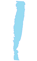
The Geographic Location Description (GLD) is a polygon starting from the seaward limit of Oregon state jurisdiction at 3 nautical miles (nm) from the shoreline, and extending seaward to a boundary line along the outer continental shelf which approximates the 500 fathom bathymetric contour. The OCMP has on file a list of geographic coordinates that form the GLD boundary line, and can make these available on a project by project basis.
Purpose:
A GLD is a geographically specific area where listed federal license or permit activities have been demonstrated to have reasonably foreseeable effects on a states coastal uses or resources. The process for creating a GLD is prescribed by the federal consistency provisions of the Coastal Zone Management Act (CZMA). Oregon established the GLD to ensure that any marine renewable energy projects within the federal waters delineated in the GLD are automatically subject to the federal consistency review process. The federal consistency process ensures that federal actions are consistent with the enforceable policies of a state’s coastal management program. The sole purpose of a GLD is to review certain federal license or permit activities outside a state’s coastal zone. The GLD does not expand the state’s boundary or jurisdiction, or dictate any decision by the state.
Supplemental_Information:
Oregon’s GLD for federal waters is within the area defined in Oregon Statewide Planning Goal 19 Ocean Resources as the Oregon Ocean Stewardship Area. The Ocean Stewardship Area is delineated and described in the Oregon Ocean Resources Management Plan, and the state’s management goals and policy interests for this area are enumerated in Part One of the Territorial Sea Plan. The OCMP has chosen the 500 fathom (fm) contour as a basis for establishment of the GLD to account for the distribution of marine resources and uses important to the state; the potential that marine renewable energy development impacts to those resources and uses would result in reasonably foreseeable effects to these coastal uses or resources (where the coastal effects could occur within and outside the state’s coastal zone), and; the maximum likely depth of future marine renewable energy development.
The GLD Analysis of Reasonably Foreseeable Effects of Federal Actions Related to Marine Renewable Energy Projects on Resources and Uses Occurring within the Federal Waters of the Oregon Ocean Stewardship Area is available for download at: http://www.oregon.gov/LCD/OCMP/docs/GLD_final.pdf
Spatial_Domain:
Bounding_Coordinates:
West_Bounding_Coordinate: -125.283122
East_Bounding_Coordinate: -123.771716
North_Bounding_Coordinate: 46.280501
South_Bounding_Coordinate: 41.975014
Keywords:
Theme:
Theme_Keyword_Thesaurus: None
Theme_Keyword: Marine Planning
Theme:
Theme_Keyword_Thesaurus: None
Theme_Keyword: Federal Consistency
Theme:
Theme_Keyword_Thesaurus: ISO 19115 Topic Categories
Theme_Keyword: boundaries
Theme_Keyword: planningCadastre
Place:
Place_Keyword_Thesaurus: None
Place_Keyword: Oregon
Place:
Place_Keyword_Thesaurus: None
Place_Keyword: Continental Shelf
Access_Constraints:
Care was taken in the creation of these themes, but they are provided "as is". The Oregon Coastal Management Program cannot accept any responsibility for errors, omissions, or positional accuracy in the digital data or underlying records. There are no warranties, expressed or implied, including the warranty of merchantability or fitness for a particular purpose, accompanying any of these products. However, notification of any errors would be appreciated.
Use_Constraints: None. Public data
Point_of_Contact:
Contact_Information:
Contact_Organization_Primary:
Contact_Organization: Oregon Coastal Management Program
Contact_Position: Marine Affairs Coordinator
Contact_Voice_Telephone: 503-934-0072
Data_Set_Credit:
Oregon Coastal Management Program, Oregon Department of Land Conservation and Development
Native_Data_Set_Environment: Version 6.2 (Build 9200) ; Esri ArcGIS 10.3.1.4959
Data_Quality_Information:
Logical_Consistency_Report:
Complete. The OCMP has on file a list of geographic coordinates that form the GLD boundary line, and can make these available on a project basis.
Lineage:
Source_Information:
Source_Citation:
Citation_Information:
Originator:
National Geophysical Data Center, NOAA, U.S. Department of Commerce
Publication_Date: 20030101
Title:
U.S. Coastal Relief Model - Central Pacific. National Geophysical Data Center, NOAA.
Edition: doi:10.7289/V50Z7152
Online_Linkage: https://www.ngdc.noaa.gov/mgg/coastal/crm.html
Type_of_Source_Media: None
Source_Citation_Abbreviation:
U.S. Coastal Relief Model - Central Pacific. National Geophysical Data Center, NOAA.
Source_Contribution:
Coastal Relief Model (CRM) from NOAA National Centers for Environmental Information as GeoTIFF. The model covered the area along the Oregon coast, from just onshore to just beyond the continental shelf, from just north of the Washington border to just south of the California border. The cell size is 3 arc-second (approximately 90 meters), vertical accuracy no better than 1 meter.
Process_Step:
Process_Description:
StateBorders - Created empty polyline data set in Oregon Lambert. Created lines starting at vertices representing junction of territorial sea boundary and state boundaries as given by BLMCountyLines_2016 and extending horizontally (direction = 0) to beyond Metric_500FathomLine.
BaseLines - From BLMCountyLines_2016, selected westernmost features of westernmost counties and exported to new data set. Copied in features of StateBorders. Selected and copied in single feature of Metric_500FathomLine which intersects both features of StateBorders.
GLD - Generated polygon from BaseLines.
Spatial_Data_Organization_Information:
Direct_Spatial_Reference_Method: Vector
Point_and_Vector_Object_Information:
SDTS_Terms_Description:
SDTS_Point_and_Vector_Object_Type: GT-polygon composed of chains
Point_and_Vector_Object_Count: 1
Spatial_Reference_Information:
Horizontal_Coordinate_System_Definition:
Planar:
Map_Projection:
Map_Projection_Name: NAD 1983 Oregon Statewide Lambert Feet Intl
Lambert_Conformal_Conic:
Standard_Parallel: 43.0
Standard_Parallel: 45.5
Longitude_of_Central_Meridian: -120.5
Latitude_of_Projection_Origin: 41.75
False_Easting: 1312335.958005249
False_Northing: 0.0
Planar_Coordinate_Information:
Planar_Coordinate_Encoding_Method: coordinate pair
Coordinate_Representation:
Abscissa_Resolution: 0.0000000266012656346959
Ordinate_Resolution: 0.0000000266012656346959
Planar_Distance_Units: foot
Geodetic_Model:
Horizontal_Datum_Name: D North American 1983
Ellipsoid_Name: GRS 1980
Semi-major_Axis: 6378137.0
Denominator_of_Flattening_Ratio: 298.257222101
Entity_and_Attribute_Information:
Detailed_Description:
Entity_Type:
Entity_Type_Label: AdminBounds_DLCD_GLD_OregonWaters
Attribute:
Attribute_Label: FID
Attribute_Definition: Internal feature number.
Attribute_Definition_Source: Esri
Attribute_Domain_Values:
Unrepresentable_Domain:
Sequential unique whole numbers that are automatically generated.
Attribute:
Attribute_Label: Shape
Attribute_Definition: Feature geometry.
Attribute_Definition_Source: Esri
Attribute_Domain_Values:
Unrepresentable_Domain: Coordinates defining the features.
Attribute:
Attribute_Label: SHAPE_Leng
Attribute_Definition: Perimeter length of feature in internal units
Attribute_Definition_Source: Esri
Attribute:
Attribute_Label: SHAPE_Area
Attribute_Definition: Area of feature in internal units squared.
Attribute_Definition_Source: Esri
Attribute_Domain_Values:
Unrepresentable_Domain: Positive real numbers that are automatically generated.
Distribution_Information:
Distributor:
Contact_Information:
Contact_Organization_Primary:
Contact_Organization: Oregon Coastal Management Program
Contact_Position: GIS Coordinator
Contact_Voice_Telephone: 971-673-0960
Distribution_Liability: See access and use constraints information.
Metadata_Reference_Information:
Metadata_Date: 20170601
Metadata_Contact:
Contact_Information:
Contact_Organization_Primary:
Contact_Organization: Oregon Coastal Management Program
Contact_Position: Marine Affairs Coordinator
Contact_Voice_Telephone: 503-934-0072
Metadata_Standard_Name: FGDC Content Standard for Digital Geospatial Metadata
Metadata_Standard_Version: FGDC-STD-001-1998
Metadata_Time_Convention: local time

Generated by mp version 2.9.40 on Tue Jun 13 15:55:12 2017