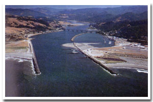
About the Rogue River Estuary
The Rogue River estuary is located on the Oregon coast at Gold Beach. The estuary is approximately 880 acres in area and has a watershed of approximately 5100 square miles.
The Rogue River estuary is designated as a Shallow Draft Development estuary under the Oregon Estuary Classification system. The geomorphology of the area is that of a River Dominated Drowned River Mouth estuary.
The Rogue River estuary is located in Curry County. The formerly mining centered economy of Curry County has largely reoriented to agriculture and timber. Port Orford cedar (Lawson Cypress) and myrtlewood are important export products. Port districts were established at Port Orford in 1919 and Gold Beach in 1955. The county has excellent grazing areas for raising cattle and sheep. The county also produces blueberries, horticultural nursery stock, and ninety percent of all Easter lilies raised in the United States. Vacation and recreational possibilities in the county draw tourists to the area and provide additional economic diversity. The first county census in 1860 showed a population of 393 in Curry County. There has been a steady increase in population with the 1997 population given at 22,200, a 14.9% increase over 1990.
The famous wilderness portion of the Rogue River Trail is only open to hikers, but the path along a lower portion of the rugged river canyon is also open to bicyclists. It's much less crowded, too. The trail contours along a forested slope above the river, dipping to a gravely beach at Big Eddy and climbing to a clifftop viewpoint at Copper Canyon. From the trees along the trail, large gray squirrels shake their bushy silver tails at passing hikers. Deer and black bear come down to the Rogue River for water, and osprey cruise above it looking for fish. In short, this is one of the best wildlife-watching areas in Southwest Oregon. |
Data for the Rogue River Estuary
[13 Records Listed]
Rogue River Estuary GIS Data |
Data Layer |
Source |
Scale |
Year |
Download |
|
OCMP |
1,000 |
1986 |
|
|
OCMP |
1,000 |
1979 |
|
|
OCMP |
1,000 |
1986 |
|
|
OCMP |
1,000 |
1986 |
|
|
OCMP |
1,000 |
1986 |
|
|
USGS |
24,000 |
1994 |
|
|
USGS |
24,000 |
1986 |
|
|
ODOT |
6,000 |
1967 |
|
|
OCMP |
0.25 m |
2005 |
|
|
OCMP |
50,000 |
2014 |
|
|
OCMP |
50,000 |
2014 |
|
|
OCMP |
50,000 |
2014 |
|
|
OCMP |
50,000 |
2014 |
|
[13 Records Listed]
Information provided by the Oregon Coastal Management Program |