About the Umpqua River Estuary
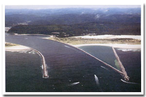
The Umpqua River estuary is located on the Oregon coast at Reedsport and Winchester Bay. The estuary is approximately 6544 acres in area and has a watershed of approximately 605 square miles.
The Umpqua River estuary is designated as a Shallow Draft Development estuary under the Oregon Estuary Classification system. The geomorphology of the area is that of a River Dominated Drowned River Mouth estuary.
The Umpqua River estuary is located in Douglas County. Actually almost the entire watershed of the Umpqua River lies within the boundaries of Douglas County. The heavily timbered county contains nearly 1.8 million acres of commercial forest lands and one of the oldest stands of old growth timber in the world. Approximately 25-30% of the labor force is employed in the forest products industry. Agriculture, mainly field crops, orchards, and livestock, is also important to the economy of the county. In addition, Nickel has been refined at Riddle since 1954. There is a significant federal presence in the regionWHERE id=1; the U.S. Forest Service and Bureau of Land Management administer more than 50% of the county's land.
Looking across the dunes, it's easy to wonder why this part of the coast has so much sand in the first place. Rivers are pulverizing rocks all the time, and grains of the toughest minerals are carried to sea as sand. Oregon's offshore sand beds are 70 to 180 feet thick. Storms and waves dredge some of this sand up to the beach each spring. Along most of the Coast, headlands and bluffs block the prevailing west winds from blowing the sand farther inland. But here, in the lowlands between Florence and Coos Bay, wave after wave of wind-driven dunes have marched ashore. |
Data for the Umpqua River Estuary
[39 Records Listed]
Umpqua River Estuary GIS Data |
Data Layer |
Source |
Scale |
Year |
Download |
|
OCMP |
1,000 |
1986 |
|
|
OCMP |
1,000 |
1979 |
|
|
OCMP |
1,000 |
1986 |
|
|
OCMP |
1,000 |
1986 |
|
|
OCMP |
1,000 |
1986 |
|
|
OCMP |
1,000 |
1979 |
|
|
OCMP |
1,000 |
1986 |
|
|
NOAA |
20,000 |
1997 |
|
|
OCMP |
10,000 |
1928 |
|
|
OCMP |
10,000 |
1971 |
|
|
OCMP |
10,000 |
1971 |
|
|
OCMP |
10,000 |
1971 |
|
|
OCMP |
10,000 |
1972 |
|
|
OCMP |
20,000 |
1972 |
|
|
OCMP |
20,000 |
1972 |
|
|
OCMP |
20,000 |
1972 |
|
|
USGS |
24,000 |
1994 |
|
|
USGS |
24,000 |
1994 |
|
|
USGS |
24,000 |
1994 |
|
|
USGS |
24,000 |
1994 |
|
|
USGS |
24,000 |
1994 |
|
|
USGS |
24,000 |
1994 |
|
|
USGS |
24,000 |
1994 |
|
|
USGS |
24,000 |
1994 |
|
|
USGS |
24,000 |
1985 |
|
|
USGS |
24,000 |
1984 |
|
|
USGS |
24,000 |
1984 |
|
|
USGS |
24,000 |
1985 |
|
|
USGS |
24,000 |
1986 |
|
|
USGS |
24,000 |
1985 |
|
|
USGS |
24,000 |
1984 |
|
|
USGS |
24,000 |
1985 |
|
|
OCMP |
24,000 |
2007 |
|
|
ODOT |
6,000 |
1967 |
|
|
OCMP |
0.25 m |
2005 |
|
|
OCMP |
50,000 |
2014 |
|
|
OCMP |
50,000 |
2014 |
|
|
OCMP |
50,000 |
2014 |
|
|
OCMP |
50,000 |
2014 |
|
[39 Records Listed]
Information provided by the Oregon Coastal Management Program |