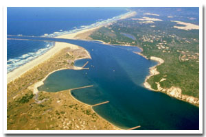
About the Siuslaw River Estuary
The Siuslaw River estuary is located on the Oregon coast at Florence. The estuary is approximately 3060 acres in area and has a watershed of approximately 4560 square miles.
The Siuslaw River estuary is designated as a Shallow Draft Development estuary under the Oregon Estuary Classification system. The geomorphology of the area is that of a Drowned River Mouth estuary.
The Siuslaw River estuary is located in Lane County. Historically, Lane county's economy has been based on timber and agriculture. Timber is important because the county is on the edge of Oregon's largest stand of timber. Agriculture has become important because of the fertile soil and moderate climate that exists in the Willamette Valley, making it one of the most productive farming areas in the nation. A major economic asset for the county is the University of Oregon in Eugene. Finally, with access to the mountains and the coast, tourism adds to the county's economic vitality. The 1860 census showed a population of 4,780 in Lane county. Since then it has seen steady, even rapid growth. The 1997 population of 308,500 represents an increase of 9.0% since 1990. In spite of this growth, the county has dropped from the second to the fourth most populous county in recent years.
Just south of Siuslaw River, the Honeyman Memorial State Park's 381-site campground is the busiest in the state. Perhaps the best way to investigate the park's scenery is on foot, hiking on a loop through the dunes. A sandy trail leads to the open dunes beside Cleawox Lake. |
Data for the Siuslaw River Estuary
[29 Records Listed]
Siuslaw River Estuary GIS Data |
Data Layer |
Source |
Scale |
Year |
Download |
|
OCMP |
1,000 |
1986 |
|
|
OCMP |
1,000 |
1979 |
|
|
OCMP |
1,000 |
1986 |
|
|
OCMP |
1,000 |
1986 |
|
|
OCMP |
1,000 |
1979 |
|
|
NOAA |
20,000 |
1992 |
|
|
OCMP |
10,000 |
1928 |
|
|
FEMA |
24,000 |
1996 |
|
|
USGS |
24,000 |
1994 |
|
|
USGS |
24,000 |
1994 |
|
|
USGS |
24,000 |
1994 |
|
|
USGS |
24,000 |
1994 |
|
|
USGS |
24,000 |
1994 |
|
|
USGS |
24,000 |
1994 |
|
|
USGS |
24,000 |
1994 |
|
|
USGS |
24,000 |
1994 |
|
|
USGS |
24,000 |
1984 |
|
|
USGS |
24,000 |
1984 |
|
|
USGS |
24,000 |
1984 |
|
|
USGS |
24,000 |
1984 |
|
|
USGS |
24,000 |
1984 |
|
|
USGS |
24,000 |
1984 |
|
|
USGS |
24,000 |
1984 |
|
|
ODOT |
6,000 |
1967 |
|
|
OCMP |
0.25 m |
2005 |
|
|
OCMP |
50,000 |
2014 |
|
|
OCMP |
50,000 |
2014 |
|
|
OCMP |
50,000 |
2014 |
|
|
OCMP |
50,000 |
2014 |
|
[29 Records Listed]
Information provided by the Oregon Coastal Management Program |