About the Lower Columbia River Estuary
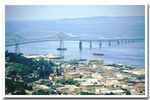
The Lower Columbia River estuary is located on the Oregon coast at Astoria. The estuary is approximately 80811 acres in area and has a watershed of approximately 259000 square miles.
The Lower Columbia River estuary is designated as a Deep Draft Develpment estuary under the Oregon Estuary Classification system. The geomorphology of the area is that of a River Dominated Drowned River Mouth estuary.
The Lower Columbia River estuary is located in Clatsop County. The principle industries of Clatsop County are fishing, lumber, and agriculture. The Port of Astoria, created in 1914, is one of 23 Oregon port districts which support the trade and commerce of Oregon. The population of Clatsop County was 34,500 in 1997, a 3.6% increase over 1990.
On the Lewis and Clark River you can paddle along the actual route of those famous explorers, following a tidewater stream from Fort Clatsop's log stockade to the city of Astoria. |
Data for the Lower Columbia River Estuary
[112 Records Listed]
Lower Columbia River Estuary GIS Data |
Data Layer |
Source |
Scale |
Year |
Download |
|
OCMP |
1,000 |
1986 |
|
|
OCMP |
1,000 |
1979 |
|
|
OCMP |
1,000 |
1986 |
|
|
OCMP |
1,000 |
1986 |
|
|
OCMP |
1,000 |
1986 |
|
|
OCMP |
1,000 |
1979 |
|
|
OCMP |
1,000 |
1986 |
|
|
NOAA |
40,000 |
1999 |
|
|
NOAA |
40,000 |
1999 |
|
|
NOAA |
40,000 |
2000 |
|
|
NOAA |
40,000 |
2000 |
|
|
NOAA |
40,000 |
2000 |
|
|
NOAA |
20,000 |
2000 |
|
|
NOAA |
40,000 |
1998 |
|
|
NOAA |
10,000 |
1999 |
|
|
USGS |
250,000 |
1973 |
|
|
OCMP |
10,000 |
1955 |
|
|
OCMP |
10,000 |
1955 |
|
|
OCMP |
10,000 |
1957 |
|
|
OCMP |
10,000 |
1957 |
|
|
OCMP |
10,000 |
1957 |
|
|
OCMP |
10,000 |
1957 |
|
|
OCMP |
10,000 |
1957 |
|
|
OCMP |
10,000 |
1955 |
|
|
OCMP |
10,000 |
1955 |
|
|
OCMP |
10,000 |
1955 |
|
|
OCMP |
10,000 |
1955 |
|
|
OCMP |
20,000 |
1969 |
|
|
OCMP |
20,000 |
1969 |
|
|
OCMP |
20,000 |
1969 |
|
|
OCMP |
20,000 |
1969 |
|
|
OCMP |
20,000 |
1969 |
|
|
OCMP |
20,000 |
1969 |
|
|
OCMP |
20,000 |
1969 |
|
|
OCMP |
10,000 |
1947 |
|
|
OCMP |
9,600 |
1945 |
|
|
OCMP |
9,600 |
1945 |
|
|
OCMP |
9,600 |
1945 |
|
|
OCMP |
9,600 |
1945 |
|
|
OCMP |
9,600 |
1945 |
|
|
OCMP |
9,600 |
1945 |
|
|
OCMP |
9,600 |
1945 |
|
|
OCMP |
9,600 |
1945 |
|
|
OCMP |
9,600 |
1945 |
|
|
OCMP |
9,600 |
1945 |
|
|
OCMP |
9,600 |
1945 |
|
|
OCMP |
9,600 |
1945 |
|
|
OCMP |
9,600 |
1945 |
|
|
OCMP |
9,600 |
1945 |
|
|
OCMP |
9,600 |
1945 |
|
|
OCMP |
9,600 |
1945 |
|
|
OCMP |
9,600 |
1945 |
|
|
OCMP |
9,600 |
1945 |
|
|
OCMP |
9,600 |
1945 |
|
|
OCMP |
9,600 |
1945 |
|
|
OCMP |
10,000 |
1947 |
|
|
OCMP |
10,000 |
1947 |
|
|
OCMP |
10,000 |
1947 |
|
|
OCMP |
10,000 |
1947 |
|
|
OCMP |
5,000 |
1948 |
|
|
OCMP |
5,000 |
1948 |
|
|
OCMP |
5,000 |
1948 |
|
|
OCMP |
5,000 |
1948 |
|
|
OCMP |
5,000 |
1948 |
|
|
OCMP |
5,000 |
1948 |
|
|
OCMP |
5,000 |
1948 |
|
|
OCMP |
5,000 |
1948 |
|
|
OCMP |
5,000 |
1948 |
|
|
OCMP |
5,000 |
1948 |
|
|
OCMP |
5,000 |
1948 |
|
|
OCMP |
5,000 |
1948 |
|
|
OCMP |
10,000 |
1948 |
|
|
OCMP |
10,000 |
1948 |
|
|
OCMP |
10,000 |
1948 |
|
|
OCMP |
10,000 |
1948 |
|
|
OCMP |
10,000 |
1948 |
|
|
OCMP |
10,000 |
1948 |
|
|
OCMP |
10,000 |
1948 |
|
|
OCMP |
10,000 |
1948 |
|
|
OCMP |
10,000 |
1951 |
|
|
OCMP |
10,000 |
1951 |
|
|
FEMA |
24,000 |
1996 |
|
|
USGS |
24,000 |
1994 |
|
|
USGS |
24,000 |
1994 |
|
|
USGS |
24,000 |
1994 |
|
|
USGS |
24,000 |
1994 |
|
|
USGS |
24,000 |
1994 |
|
|
USGS |
24,000 |
1994 |
|
|
USGS |
24,000 |
1994 |
|
|
USGS |
24,000 |
1994 |
|
|
USGS |
24,000 |
1994 |
|
|
USGS |
24,000 |
1994 |
|
|
USGS |
24,000 |
1994 |
|
|
USGS |
24,000 |
1985 |
|
|
USGS |
24,000 |
1985 |
|
|
USGS |
24,000 |
1986 |
|
|
USGS |
24,000 |
1985 |
|
|
USGS |
24,000 |
1985 |
|
|
USGS |
24,000 |
1985 |
|
|
USGS |
24,000 |
1986 |
|
|
USGS |
24,000 |
1986 |
|
|
USGS |
24,000 |
1985 |
|
|
USGS |
24,000 |
1987 |
|
|
USGS |
24,000 |
1985 |
|
|
USGS |
24,000 |
1999 |
|
|
USACE |
24,000 |
2010 |
|
|
LCREP |
10,000 |
2012 |
|
|
LCREP |
10,000 |
2012 |
|
|
OCMP |
50,000 |
2014 |
|
|
OCMP |
50,000 |
2014 |
|
|
OCMP |
50,000 |
2014 |
|
|
OCMP |
50,000 |
2014 |
|
[112 Records Listed]
Information provided by the Oregon Coastal Management Program |