About the Pillar and Pyramid Rock Rocky Shore Area
Description
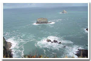
Pyramid Rock is approximately 100 ft high and covered only slightly with very sparse vegetation. Pillar Rock (offshore Cape Meares) is approximately 85 ft high with sparse vegetative cover. |
|
Designation
Offshore rocks are part of the USFWS Oregon Islands National Wildlife Refuge (NWR) and access is prohibited, as they are important habitat for birds and marine mammals. |
| |
|
|
Key Resources
Seabird colonies including common murres, Brandt’s cormorants and brown pelicans. |
|
What can you do here?
Public access is prohibited. However, typical ocean recreational activities occur around the rocks such as boating and fishing. |
Getting to the Rocky shore at Pillar and Pyramid Rock
Access is by boat only, although public entry onto any of the offshore islands in the Oregon Islands NWR is prohibited.
Who Owns this Site?
Submerged and intertidal lands: Division of State Lands; offshore rocks above Mean High Water (MHW): U.S. Fish and Wildlife Service. |
|
Who Manages this Site?
 The rocks above MHW are managed by the USFWS as part of the Oregon Islands National Wildlife Refuge. The rocks above MHW are managed by the USFWS as part of the Oregon Islands National Wildlife Refuge. |
|
Data for the Pillar and Pyramid Rock Rocky Shore
[0 Records Listed]
Pillar and Pyramid Rock Rocky Shore GIS Data |
Data Layer |
Source |
Scale |
Year |
Download |
|
|
|
|
|
[0 Records Listed]
Information compiled by Laurel Hillmann, NOAA Coastal Management Fellow, OPRD |