About the Meyers Creek Rocks Rocky Shore Area
Description
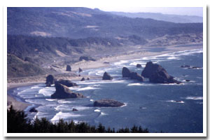
rocky shoreline is located approximately seven miles south of Gold Beach, in Curry County, Oregon. |
|
Designation
The beaches and rocky shores of Oregon are part of Oregon’s Ocean Shore Recreation Area and the offshore rocks and islands are part of the Oregon Islands National Wildlife Refuge (NWR). |
| |
|
|
Key Resources
Intertidal and subtidal habitat (with limited kelp beds), close-to-shore offshore rocks, with use by seabirds. |
|
What can you do here?
Beachcombing, tidepooling, sightseeing, and boardsailing are popular recreational activities within this section of Oregon’s coastline. |
Getting to the Rocky shore at Meyers Creek Rocks
The beach and rocky area on the landward side of the rocks is accessible via a 2-mile long hike down a primitive (and somewhat difficult) trail from the top of Cape Sebastian or along the beach (approximately 1/2 mile) from a pull off, off HWY 101 to the south of the park. Visual access to this shoreline is stunning from a large scenic overlook along Highway 101 near the mouth of Meyers Creek. Access to the offshore rocks is prohibited, since they are part of the Oregon Islands NWR and are important habitat for seabirds and marine mammals.
 Public Access Option 1 for Meyers Creek Rocks Rocky Shore Public Access Option 1 for Meyers Creek Rocks Rocky Shore
 Public Access Option 2 for Meyers Creek Rocks Rocky Shore Public Access Option 2 for Meyers Creek Rocks Rocky Shore
Who Owns this Site?
Submerged and submersible (intertidal) lands: Division of State Lands; rocks above Mean High Water: U.S. Fish and Wildlife Service. Part of the upland area on the southern end of this site is owned and managed by Oregon Parks and Recreation Department (OPRD) as Pistol River State Scenic Viewpoint. |
|
Who Manages this Site?
 Offshore rocks are managed as part of the Oregon Islands National Wildlife Refuge, which is managed by the US Fish and Wildlife Service (USFWS). OPRD manages the southern uplands of this section of coastline as Pistol River State Scenic Viewpoint (SSV). Pistol River SSV is part of OPRD Area 4 and the Harris Beach Management Unit. Offshore rocks are managed as part of the Oregon Islands National Wildlife Refuge, which is managed by the US Fish and Wildlife Service (USFWS). OPRD manages the southern uplands of this section of coastline as Pistol River State Scenic Viewpoint (SSV). Pistol River SSV is part of OPRD Area 4 and the Harris Beach Management Unit. |
|
Data for the Meyers Creek Rocks Rocky Shore
[0 Records Listed]
Meyers Creek Rocks Rocky Shore GIS Data |
Data Layer |
Source |
Scale |
Year |
Download |
|
|
|
|
|
[0 Records Listed]
Information compiled by Laurel Hillmann, NOAA Coastal Management Fellow, OPRD |