About the Devil's Backbone Rocky Shore Area
Description
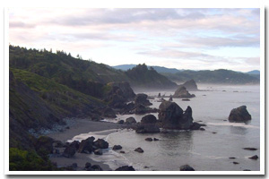
2.7 miles of cliffs, offshore rocks, and rocky intertidal habitat located about midway between Port Orford and Gold Beach in Curry County Oregon. |
|
Designation
The beaches and rocky shores of Oregon are part of Oregon’s Ocean Shore Recreation Area and the offshore rocks and islands are part of the Oregon Islands National Wildlife Refuge. |
| |
|
|
Key Resources
Rocky intertidal habitat; six seabird colony sites. Harbor seals use the area as a haulout. |
|
What can you do here?
Activities include beachcombing, tidepooling, sport fishing, bird watching, SCUBA diving, and sea kayaking. The Sisters Rock area receives relatively little use due to the undeveloped nature of this site. Vehicular access is no longer possible by way of the gravel road; however, visitors continue to travel down by foot. Devil's Backbone and the rocky shoreline to the north receive little use due to difficult or restricted access. |
Getting to the Rocky shore at Devil's Backbone
Access to the Sisters Rocks area is from a short gravel road off of Highway 101 approximately 6 miles south of Humbug Mountain State Park. The gravel road is not open to vehicular traffic and there is a gate blocking non-pedestrian traffic. Most of the area south of Sisters Rocks to Devils Backbone is private and has restricted access.
Who Owns this Site?
Submerged and submersible (intertidal) lands: Division of State
Lands; several small offshore rocks above Mean High Water: U.S. Fish and Wildlife
Service; dry sands beach areas and the Sisters Rock area proper: Oregon Parks and Recreation Department; other adjacent uplands: private ownership. |
|
Who Manages this Site?
  Sisters Rock State Natural Area is under the ownership and management of Oregon Parks and Recreation Department. It is part of the South coast management area (area 4) and the Cape Blanco Management Unit. Oregon Parks and Recreation Department manages the ocean shore recreation area. Offshore rocks are managed by USFWS as part of the Oregon Islands National Wildlife Refuge. Sisters Rock State Natural Area is under the ownership and management of Oregon Parks and Recreation Department. It is part of the South coast management area (area 4) and the Cape Blanco Management Unit. Oregon Parks and Recreation Department manages the ocean shore recreation area. Offshore rocks are managed by USFWS as part of the Oregon Islands National Wildlife Refuge. |
|
Data for the Devil's Backbone Rocky Shore
[0 Records Listed]
Devil's Backbone Rocky Shore GIS Data |
Data Layer |
Source |
Scale |
Year |
Download |
|
|
|
|
|
[0 Records Listed]
Information compiled by Laurel Hillmann, NOAA Coastal Management Fellow, OPRD |