About the Heceta Head Rocky Shore Area
Description
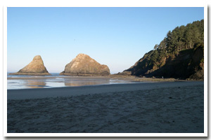
0.75 miles of steep and virtually inaccessible cliffs and associated rocks approximately 10 miles north of Florence. Limited intertidal habitat is accessible from the beach at the Heceta Head Lighthouse State Scenic Viewpoint. |
|
Designation
The beaches and rocky shores of Oregon are part of Oregon’s Ocean Shore Recreation Area. |
| |
|
|
Key Resources
Seabird nesting sites; marine mammal haulout site to the south. |
|
What can you do here?
Recreation at this site includes sightseeing on the cliff above (including viewing the historic lighthouse), general beach recreation including some shore fishing, photography and tidepooling. |
Educational Opportunities
Oregon Parks and Recreation Department rangers occasionally lead rocky shore interpretive walks at this location.
Getting to the Rocky shore at Heceta Head
Very difficult access by trail to some points on the cliff; others inaccessible. Some limited intertidal habitat is accessible from both ends of the beach at Heceta Head Lighthouse State Scenic Viewpoint.
 Public Access Option 1 for Heceta Head Rocky Shore Public Access Option 1 for Heceta Head Rocky Shore
Who Owns this Site?
Submerged and submersible (intertidal) lands: Division of State Lands; adjacent beach at the mouth of Cape Creek and some upland areas: Oregon Department of Parks and Recreation (OPRD). |
|
Who Manages this Site?
 OPRD manages Heceta Head Lighthouse State Scenic Viewpoint (formerly Devil's Elbow SP) as part of Area 3 in the Beachside Management Unit. The beaches and rocky shores of Oregon are part of Oregon’s Ocean Shore Recreation Area, which is managed by Oregon Parks and Recreation Department. OPRD manages Heceta Head Lighthouse State Scenic Viewpoint (formerly Devil's Elbow SP) as part of Area 3 in the Beachside Management Unit. The beaches and rocky shores of Oregon are part of Oregon’s Ocean Shore Recreation Area, which is managed by Oregon Parks and Recreation Department. |
|
Data for the Heceta Head Rocky Shore
[3 Records Listed]
Heceta Head Rocky Shore GIS Data |
Data Layer |
Source |
Scale |
Year |
Download |
|
USGS |
24,000 |
1994 |
|
|
USGS |
24,000 |
1994 |
|
|
USGS |
24,000 |
1984 |
|
[3 Records Listed]
Information compiled by Laurel Hillmann, NOAA Coastal Management Fellow, OPRD |