About the Cape Kiwanda Head Rocky Shore Area
Description
Cape Kiwanda is a sandstone headland with cliffs approximately 100 ft or more in height with an easily accessible intertidal area on the south side. The rocky shore areas of Cape Kiwanda (one out of seven marine gardens) are adjacent to Pacific City, Oregon. |
|
Designation
 Cape Kiwanda Marine Garden encompasses “all rocky areas, tide pools, and sand beaches situated between extreme high tide and extreme low tide lying between the sand beach on the north and the sand beach on the south of Cape Kiwanda. Includes rocky areas abutting the sand beaches on the north and south sides of the headland.” Cape Kiwanda Marine Garden encompasses “all rocky areas, tide pools, and sand beaches situated between extreme high tide and extreme low tide lying between the sand beach on the north and the sand beach on the south of Cape Kiwanda. Includes rocky areas abutting the sand beaches on the north and south sides of the headland.” |
| |
|
|
Key Resources
Intertidal communities and some seabird nesting on associated cliffs and offshore rocks (including Haystack Rock which is just offshore). |
|
What can you do here?
Popular recreational uses of the area include kite flying, beachcombing, boating, surfing, tidepooling and hang-gliding. Collection of shellfish and marine invertebrates, except single mussels for bait is prohibited in Cape Kiwanda Marine Garden. |
Educational Opportunities
Cape Kiwanda Education Learning Program (KELP), a volunteer based interpretive program, offers free seasonal interpretive services to the public which may include on-site touch-tanks and volunteers available to answer questions about the tidepools.
Getting to the Rocky shore at Cape Kiwanda Head
Beach access is afforded on both the north and south ends of the Cape, although the primary access point is via the public parking area in downtown Pacific City.
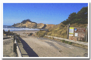
 Public Access Option 1 for Cape Kiwanda Head Rocky Shore Public Access Option 1 for Cape Kiwanda Head Rocky Shore
Who Owns this Site?
Submerged and intertidal lands: Division of State Lands; the beach and part of the upland areas are owned by Oregon Parks and Recreation Department as Cape Kiwanda State Natural Area. |
|
Who Manages this Site?
  Oregon Parks and Recreation Department (OPRD) manages Cape Kiwanda State Natural Area for general recreation and natural resource use. Cape Kiwanda is part of OPRD Area 1 and the Cape Lookout Management Unit. Beach and intertidal areas are managed by OPRD as part of the ocean shore. ODFW manages the site as a Marine Garden. Oregon Parks and Recreation Department (OPRD) manages Cape Kiwanda State Natural Area for general recreation and natural resource use. Cape Kiwanda is part of OPRD Area 1 and the Cape Lookout Management Unit. Beach and intertidal areas are managed by OPRD as part of the ocean shore. ODFW manages the site as a Marine Garden. |
|
Data for the Cape Kiwanda Head Rocky Shore
[2 Records Listed]
Cape Kiwanda Head Rocky Shore GIS Data |
Data Layer |
Source |
Scale |
Year |
Download |
|
ODFW |
100,000 |
2008 |
|
|
ODOT |
6,000 |
1967 |
|
[2 Records Listed]
Information compiled by Laurel Hillmann, NOAA Coastal Management Fellow, OPRD |